Printable Holiday: K2 Base Camp & Gondogoro La trek
K2 Base Camp & Gondogoro La trek
COUNTRIES VISITED: Pakistan
TRIP CODE: K2G
DURATION: 21 Days
TRIP TYPE: Mountaineering
TRIP LEADER: International Leader
TRIP GRADE: Strenuous
GROUP SIZE: 5 - 10 people
TRIP STYLE: Camping
NEXT DEPARTURE: 11 Jul 2027
REVIEWS: 5 Stars Based On 8 Reviews
TREES PLANTED: 8 Trees Planted for each Booking
Overview & Itinerary
Details
This is a challenging trek requiring technical mountaineering skills, we follow Baltoro glacier to Concordia and K2 Base Camp then cross the Gondogoro La pass at 5,560m
The journey starts with a flight from Islamabad to Skardu in Gilgit-Baltistan. From the plane, you will see spectacular views of the Karakoram including Nanga Parbat. After several nights in Skardu, we take jeep transport to the road head of the trek at Jhola.
Mount K2 at an altitude of 8,611m is the second-highest mountain in the world. It is a steep mountain and the climbing routes are technical. The first ascent was in 1954 by an Italian expedition following the Abruzzi spur.
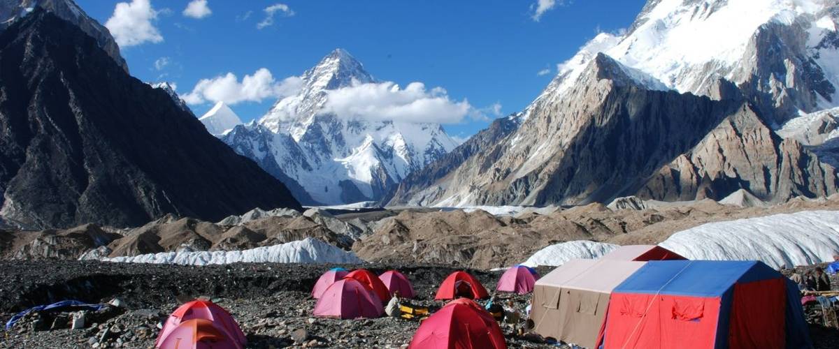
The trekking route up the Baltoro glacier has superb mountain views all the way up to Concordia. On our walk, we will see the Trango Towers, Muztagh Tower, Masherbrum, K2 and Broad Peak among many others. Galen Rowell described Concordia in his book as the “Throne Room of the Mountain Gods”. We camp at Concordia and will see its unique panorama of 7,000m and 8,000m mountains and impressive views of the highest peak, K2.
From Concordia, we start the challenging trek out over Gondogoro La. A local team from Hushe place ropes on the route up and down. You need to have mountaineering skills to cross this technical pass. The mountain view from the top is superb. We see the slender lines of Leila peak on the Hushe side. On the other side, we see many peaks of the high Karakoram.
Every year in mid-July we organise two groups to K2 Base Camp starting at the same time in Islamabad. The K2 Base Camp & Concordia group will walk back down Baltoro glacier from Concordia. Whereas the K2 Base Camp & Gondogoro La group will cross this high pass at an altitude of 5,560m.
Reasons To Choose Us
We are Karakoram trekking specialists having operated trips in Pakistan since 2004. Roland Hunter has designed the itinerary from his first-hand experience of this trek.
The Mountain Company has organised fourteen successful K2 Base Camp treks. For more information on how these treks went please take a look at our Trip Reports.
We work with some of the best mountain leaders with deep knowledge of trekking in Karakoram. Unlike many other operators, we use trained international leaders for this trip.
We have included a gradual ascent profile in our itinerary for this trekking holiday. This will help you acclimatise to the high altitude.
We organise our K2 Base Camp & Concordia trek at the same time as our K2 & Gondogoro La trek. Our international leader will lead both groups on the approach to K2 Base Camp. On the descent from Concordia, this leader will go over Gondogoro La. One of our Pakistan guides will lead the K2 Base Camp group descending Baltoro. The two groups will meet up again at Concordia Motel in Skardu on Day 18.
Weather forecasts for the K2 region during your trek.
We send a Thuraya satellite phone on our group treks in Pakistan. Your leader will have reliable communications for logistics, planning and group safety. We use GPS to upload your location daily onto Google Maps to track your progress during the trek.
We provide a range of tasty meals for breakfast, lunch, and supper. For breakfast, we provide fresh coffee from our Bialetti Moka coffee machine.
We bring a comprehensive medical aid kit. There will also be a portable altitude chamber (PAC or Gamow bag).
Our team with first-hand knowledge of this trek provides pre-trip support.
Itinerary
Day 1: Arrive in Islamabad (540m)
Flight: Arrival in IslamabadSightseeing: Sightseeing in IslamabadMeals: No mealsAccommodation: Hotel Hillview in Islamabad
We meet you on arrival at Islamabad airport and drive to the hotel. At some point during the day, your leader will give the trek briefing and check your gear. The rest of the day is free to explore Islamabad and pack your bags.
Day 2: Fly to Skardu (2,228m)
Flight: Flight to SkarduMeals: Breakfast, Lunch and DinnerAccommodation: Concordia or K2 Motel in Skardu
This morning we take the PIA flight to Skardu in Gilgit-Baltistan.
Day 3: Jeep drive to Askole (3,048m)
transport: Drive by jeep to Askole (6 hours)Meals: Breakfast, Lunch and DinnerAccommodation: Camping
We have a spectacular drive on a winding jeep trail with several steep sections. A short distance from Skardu we cross the Indus river on a bridge near the confluence with the Shigar river. We drive up the wide open Shigar valley passing some larger villages and their fields.
Further up at the next river confluence we follow the Braldu river upstream. As we ascend the gorge it gets steeper and more arid. We pass a few villages with green fields from irrigation and shaded by apricot trees. Askole is the last village in this valley.
The time to drive to Askole depends on the condition of the road which varies year to year. The Braldu section is prone to landslides and these can block the road. The locals are very good drivers and will come up with a solution to clear the road or use jeeps on the other side.
After Askole, we start the trek by following the trail next to the Braldu river. Once passed the snout of the Biafo glacier we arrive at Korofong. We cross a tributary called Dumordo River on a new bridge to arrive at Jhola. In the past, the locals used an old trolley system or “jhola” with a bucket to cross the river hence the name of this place. The views from here are impressive with Bakhor Das (5,809m) and Paiju Peak’s needles in the distance.
If it is a sunny day then it can be very hot with temperatures often approaching 40C. It is important to bring plenty of water (at least three litres), wear a sun hat and apply plenty of sun cream.
Day 5: Trek to Paiju (3,383m)
Distance: Walking 20km (6 to 7 hours)Ascent: Walking ascent 620mDescent: Walking descent 350mMeals: Breakfast, Lunch and DinnerAccommodation: Camping
From Jhola, we follow the main trail to K2 Base Camp via Bardumal camp (also known as Skambong Scok). We follow a trail around a corner to join the Braldu valley again. Bardumal camp is in a large flat area next to the river. After Bardumal we have to cross several side rivers that sometimes involve a river crossing by foot if the bridges have been washed away. These rivers are glacier-fed and on a hot day, they will be fast-flowing due to snow melt. Paiju is a green oasis under the shadows of Paiju Peak (6,611m). From this camp, we have the first views of the immense Baltoro Glacier.
After an hour from Paiju, we start walking on the Baltoro glacier for the first time. The path on the glacier is on rocky moraine and we should take care as the surface is uneven. We recommend the use of trekking poles. For the next two days the glacier has many ice ridges so we have to ascend and descend these slopes as we head up.
We will stop for lunch at the old campsite at Lilligo. After this break we cross below the snout of the Lilligo Glacier and back on to the Baltoro. The trail is indistinct in places and it is easy to lose your way. It is important for the group to stay together with local guides to show the way. We walk up and down several moraine ridges before arriving at the Khoburtse campsite.
From camp we follow a trail along the lateral moraine next to the glacier. Further along we descend down onto Baltoro and pass two side glaciers. It is a short day but quite hard work as we walk up the undulating moraine, gaining height all the way. During the walk there are superb views of Trango & Cathedral spires. We also see Mount Uli Biaho (6,005m) and Mount Biale (6,841m). The camp at Urdukas is very impressive with views over the Baltoro and to these mountains. As we are over 4,000m we stay at Urdukas for two nights for acclimatisation to the high altitude.
Day 8: Acclimatising day at Urdukas (4,130m)
Meals: Breakfast, Lunch and DinnerAccommodation: Camping
We have found with past groups that taking a rest day at Urdukas has worked well. The advantages of spending an extra night here are:
It helps the acclimatisation process and has proved to be more effective than a rest day at Paiju (3,383m).
There is a walk behind the campsite through grassy slopes full of alpine flowers. By climbing high and sleeping low is the best way to help your body adapt to high altitude.
This is the last campsite on grassy slopes off the main glacier. There are also facilities for washing and cleaning.
From camp we descend onto the glacier and we will stay on the ice until our return to Urdukas. As we are higher up the Baltoro glacier the glacial ice is flatter. The walking is easier than before as we cross fewer moraine ridges. We walk in the centre of the glacier and have superb views of both sides lined by high mountains. There are views of Muztagh (7,270m) and Masherbrum (7,800m). We see Gasherbrum IV (7,925m) at the head of the Baltoro glacier near Concordia. The campsite at Goro II is on the glacier. There are ledges on the rock levelled out for the tents.
We walk up the centre of the Baltoro to Concordia. Now we are higher on the glacier there is ice underfoot and less rock. The walking is easier as the Baltoro is much flatter here. Concordia is where the Baltoro, Abruzzi and Godwin Austen glaciers converge. This is an incredible place surrounded by high peaks. We get our first views of the magnificent K2 to the North. We can also see Broad Peak and some of the Gasherbrum group.
Day 11: Trek to K2 Base Camp (5,150m) and back to Broad Peak Base Camp (4,960m)
From Concordia the route passes through jumbled ice fins and moraine ridges. This is the fracture zone where Godwin Austen glacier meets the Baltoro. After crossing this area we start walking on the flatter glacier towards Broad Peak. Godwin Austen glacier has alternating stripes of pure ice and rocky moraine. Sometimes we walk on the flatter ice as this is easier to walk on than the loose rock on the medial moraine.
After reaching Broad Peak Base Camp we continue the walk up to K2 Base Camp and to Gilkey Memorial. On the return we walk back to Broad Peak Base Camp where we camp for the night. We place our tents on moraine near the base of the climbing route on Broad Peak. One of the best views of K2 is from Broad Peak Base Camp.
This morning we hike back down to Concordia following the same trail as our ascent yesterday. Once back at Concordia the trek crew will make preparations for the split in the two groups tomorrow. Our international leader will take our K2 & Gondogoro La group out over Gondogoro La. Our K2 Base Camp group will descend the Baltoro with our Pakistani guide. The two groups will meet up again in Skardu after the trek.
From Concordia we head to the South-East along the Upper Baltoro glacier. We pass Mitre Peak and walk to the South on the Vigne glacier. Today the walk is along flat sections of glacier. There are only a few moraine ridges to scramble over to reach the Vigne Glacier. We get spectacular views especially of the ice flutings on Vigne Peak (6,281m) and Khumil Gri (6,840m).
There is a section of glacier with crevasses before arriving at Ali camp. As this is a dry glacier we avoid these holes by weaving our route through the crevasses. On arrival at Ali camp we meet members of the Hushe Rescue Team. They are responsible for maintaining the fixed rope on Gondogoro La. They will assist our crossing and climb with us to the top of the pass.
Day 14: Cross the Gondogoro pass (5,560m), trek to Khuspang (4,600m)
This is a tough day at high altitude but the views from the top of the pass make the effort worthwhile. Four 8000m peaks can be seen from the Karakoram side of the pass. The other way we look down the Hushe valley with the beautiful Leila peak.
We will start early around midnight. This is to minimise the risk of rockfall on the descent down the Hushe side of the pass. The ascent of the pass is on moderate angled snow slopes. You will need to use crampons and ice axes for security on the Vigne side of the pass. There is rope for the steeper sections. You will use a harness, ascender and a carabiner and sling on the rope for safety. If the snow conditions are good we ascend the pass quite fast. It takes about 5 hours from leaving Ali camp to the top of Gondogoro La.
The Hushe side of the pass can be a tricky descent although there are ropes in place at the top. The slope starts at a sustained 50 degrees on snow and finishes on loose scree towards the bottom. From there we walk down a rocky slope until we meet a trail heading down the lateral moraine. Further down we pass grassy areas with flowers. Finally we arrive at the green oasis of Khuspang. You can now put your feet up and have a cup of tea.
The crossing of the Gondogoro La is dependent on good weather and conditions. If it is not possible to ascend the pass in a safe manner we will walk back down the Baltoro glacier to Askole. Our itinerary maximises our chances of crossing the pass because:
You should be well acclimatised due to the gradual ascent on the trek.
We have two buffer days in case of delays or bad weather on Day 16 & 17 of the itinerary.
We pay for monitor weather forecasts for K2 region and are sent by SMS text directly to the leader's satellite phone.
We always send an international leader on this trek working with our Pakistan guides. Having strong leadership is key for a success trip.
We have a strong track record organising treks in Pakistan since 2004 with most of our groups having successfully crossed Gondogoro La.
Shortly after leaving Khuspang we walk onto the Gondogoro glacier. We pick our way across the moraine and ice down the centre. We cross the glacier up to Dalsangpa which means 'field of flowers'. There is a spectacular view of Masherbrum and its glacier cascading down Masherbrum Pass.
It is a beautiful walk to Shaisho as we pass yak pastures and see the first trees since Paiju. Shaisho is a small settlement with a shop run by a friendly local. This person has worked as a High Altitude Porter on a K2 expedition.We camp here for the night and enjoy the higher levels of oxygen and warmer temperatures.
We have an easy walk out along the river and then through fields to the village of Hushe.
Day 17: Rest day in Hushe
Day 18: Drive by jeep to Skardu (2,228m)
transport: Drive by jeep to Skardu (6 hours)Meals: Breakfast, Lunch and DinnerAccommodation: Concordia or K2 Motel in Skardu
In the morning we have a beautiful 6 hour drive through villages back to Skardu.
Day 19: Fly to Islamabad
Flight: 1) Flight to Islamabadtransport: 2) Bus to Gilgit (4 hours)Meals: BreakfastAccommodation: 1) Hotel Hillview in IslamabadAccommodation: 2) Hotel in Gilgit
We plan to take the early morning flight to Islamabad (inshallah!).
Day 20: Buffer or contingency day
transport: 2) Drive to Islamabad on KKH (8 to 9 hours)Meals: BreakfastAccommodation: Hotel Hillview in Islamabad
Today is a buffer day in case of any delays experienced along the way. If we managed to take the flight on time yesterday then we will spend the day in Islamabad. In the evening we have a group meal to celebrate our journey in the Karakoram mountains of Pakistan.
Day 21: Fly back home
Flight: Flight back homeMeals: Breakfast
Transfer to Islamabad airport for the flight back home. End of trip.
Dates & Prices
We provide an early bird discount for the first people paying their deposits to make up our minimum group size
2027
Dates
Trip Leader
Price
Single Supplement: Room/Tent
Availability
11 Jul 2027 to 31 Jul 2027
International Leader
US$4,595pp US$4,395pp
Room: US$450pp Tent: US$595pp
5 Left to Guarantee Early Bird Discount
2028
Dates
Trip Leader
Price
Single Supplement: Room/Tent
Availability
09 Jul 2028 to 29 Jul 2028
International Leader
US$4,450pp
Room: US$495pp Tent: US$650pp
5 Left to Guarantee
What's Included
Internal flights. The flights are Islamabad - Skardu - Islamabad. If cancelled then we will drive on Karakoram Highway.
Twin share rooms at hotels.
Breakfast only in Islamabad, all meals included in Skardu and while on trek.
Twin share tents while on trek. These are domed tents with space for two people sharing plus gear.
Trekking arrangements. Including permits and fees, tents, International and Pakistan guides, porters and cooks.
Porterage. The allowance for your main bag is 20kg.
Weather forecasts for the K2 region during your trek.
Thuraya satellite phone for organising logistics and medical evacuations. It can also be also used for personal calls at extra cost.
GPS tracking on Google Maps. Your friends and family can track your progress during the trek.
Full financial protection for bookings from the UK (ATOL) and internationally (ABTOT). Our Air Travel Organiser’s Licence (ATOL) number is 10921. Our Association of Bonded Travel Operators Trust (ABTOT) membership number is 5365).
Pre-departure support and advice from The Mountain Company. We are available by email, phone, Zoom or face-to-face meetings.
What's Not Included
International flight to/from Islamabad.
Travel & trekking insurance.
Pakistan visa for 30 days.
Lunch and evening meals in Islamabad.
Personal clothing & equipment, please see Practical Information for kit list.
Tips to the trek crew. Each trekker should budget for giving tips into the group fund. This should be in the region of £140 or US$175.
Other items not listed in “What is included”.
Accommodation
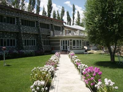
K2 Motel in Skardu
K2 Motel is in a lovely position overlooking the Indus river. It is the classic place that many expeditions and trekking groups have stayed over the years.
It is a short walk taking about 15 minutes into the main part of Skardu town and the bazaar. K2 Motel has 28 rooms and a restaurant plus a garden at the back of the property.
Hill View Hotel in Islamabad
Hotel Hill View is a modern hotel and is a comfortable base for our groups while in Islamabad. It is a short walk to Jinnah market where there are good restaurants and shops. There is wifi at the hotel.
Practical Information
A Typical Day On Camping Trek in Pakistan
We provide a comfortable experience on our camping style treks in Pakistan. Our team works hard to support you so that you can relax and enjoy the trek. We provide personal tents, mess tent, kitchen tent and toilet tent(s). The camp will be set up and dismantled by the trek crew. We bring along a cook and kitchen helpers to provide the meals.
The day starts with an early morning mug of tea in the mess tent. Before breakfast you pack your overnight gear into your duffel bag. During breakfast the trek crew pack away the tents. The porters arrange their loads and set off on the trail in the cool of the morning. After breakfast, between 7am and 8am, we start walking.
The pace of the trek is moderate as there is plenty of time in the itinerary to reach the camp for tonight. There will be plenty of time to enjoy the scenery, take photos and explore the local villages. Lunch will be around midday at a spot by the side of the trail. Our cooks prepare lunch for us and the food is usually ready by the time the group arrives.
After lunch we continue the walk and on most days we arrive to camp by mid afternoon. Some of the trek crew would have gone ahead of the group to set up camp and to put up the tents. On arrival to camp you will get a hot drink and biscuits. In the evening our cook will provide a three course meal in the mess tent around 6pm.
After supper the leaders will discuss the plan for the next day. Afterwards people might stay in the mess tent chatting about the day’s events or playing cards. After a tiring day most people head to their tent quite early for the night. Tomorrow is likely to be very similar as today! The only difference is that if we are crossing a high pass or climbing to a summit we leave camp earlier in the morning.
Food provided on Camping Trek in Pakistan
While on a camping style trek in Pakistan we provide tasty and nutritional food. We make sure there is more than enough quantity to go around as trekkers will be hungry after a long day on the trail. Over the years we have worked on increasing the variety of the menus. We have expanded the list of ingredients provided to the cooks so they have more to work with.
For breakfast we provide porridge or cereal, toast or chapatis and eggs. There will be hot drinks including tea, hot chocolate and coffee. We provide fresh coffee from our Bialetti Moka coffee machine.
For lunch we stop at a convenient spot with water at the side of the trail. The cook and kitchen walk ahead of the group in the morning and lunch should be ready shortly after our arrival. After lunch we have time to relax before starting to walk again in the afternoon.
On arrival at camp in the afternoon you have biscuits and a hot drink such as tea or coffee. Around 6pm we serve a three course meal in the mess tent. The starter is often soup with popcorn or poppadoms. We have a range of main dishes and carbohydrates including rice, potatoes or pasta. Most meals are also served with delicious flat breads made fresh by the cooks.
We cater for a variety of dietary requirements. Our meals are suitable for vegetarians. If there is a meat dish then we also provide vegetarian options as standard. During booking we find out if you have any dietary needs and agree upon meal plans before departure. If you have any questions about the food provided please get in touch with us to discuss further.
Communications
We bring a Thuraya satellite phone for logistical, safety and personal use. Personal calls charged at £4 (US$5 or €4.50) per minute and £2 (US$3 €4.50) to send and receive SMS text.
Kit List for K2 Base Camp & Gondogoro La trek
This is the mandatory kit list for the safety of everyone in the group and to ensure a successful trek. You must have the following items tailored for the K2 Base Camp & Gondogoro La trek. The group leader will check your gear in Islamabad or Skardu before departure for the trek.
As a reminder, the weather on this trek will vary from season to season and day to day as you ascend to higher elevations. At the start of the trek, you will experience very hot conditions with temperatures up to 40 Celsius. You experience the coldest temperatures in Broad Peak Base Camp at an altitude of 4,960m. Overnight lows here will be down to around -10 Celsius.
You should bring a rucsac or backpack for the gear required during the day. Your pack should contain items such as warm clothes, a jacket, a camera, water bottles, a personal first aid kit and snacks. The weight limit is 5kg. A porter will carry the rest of your personal equipment packed in a duffel or kit bag. The weight limit for your duffel bag is 20kg. Please mark your bag on the outside for easy identification.
Print the kit list and tick items off as you pack them then weigh your kit bag before you come on trek.
Footwear
B2-rated mountaineering boots. For the day crossing Gondogoro La high pass.
Walking Boots. A pair of water-repellent boots with ankle support. Boots must be in good condition, the best approach is to get new boots and break in before the trek. Over the years we have had several boots fall apart so you should also bring trail shoes as a backup.
Trail shoes. Used around camp and as a replacement if your walking boots fall apart!
Sandals. Enclosed sandals are best to protect your feet during river crossings. Required for river crossings as well as two trekking poles.
Walking socks.
Clothing
Waterproof and Windproof jacket (with hood) and trousers (Goretex or similar). For use if it rains or snows during the trek and in windy conditions.
Trekking trousers.
Soft Shell Trousers.
Long-sleeved tops or shirts (not cotton).
Micro fleece.
Mid to heavyweight fleece or synthetic/ primaloft top.
Sleeveless/ gilet or body warmer type fleece / synthetic top. This will help keep your core warm while not bulking when layering up. Gilet is used in combination with base layers, other fleeces and a down jacket. This provides the most warmth and insulation.
Thermals or base layer for top & bottom (merino wool or synthetic).
Medium-weight down jacket.
Head and Gloves
Fleece gloves.
Mountaineering gloves.
Wool or fleece hat.
Sun hat.
Bandana or scarf (eg. Buff Headwear).
Head torch. Bring extra batteries.
Sunglasses. They should have side protection or a wraparound design.
For walking on the glacier
Trekking poles. Two poles are mandatory for your safety. These will be helpful on steep sections of the trail and river crossings. Also for walking on snow or ice higher up.
Kahtoola Microspikes or YakTrax Summits. These are for your security when descending passes with snowy or icy conditions. They fit onto your walking boots.
Gaiters. A pair of knee-high gaiters is used to keep boots dry if walking through snow or on wet ground.
Climbing equipment for Gondogoro La
Climbing harness. Plus two 60cm slings, four screw gate carabiners, Figure 8 belay device and 3m of 5mm static cord for prusiks.
Jumar ascender (eg. Petzl handled ascender).
Crampons. The best are universal crampons that you can use with trekking boots. Such as Stubai Universals or Kahtoola KTS crampons.
Mountaineering ice axe with leash.
Climbing helmet (mandatory as there is a risk of rockfall on the Gondogoro La).
Personal equipment
Sleeping bag. Overnight lows down to -10 Celsius.
Fleece or silk liner for your sleeping bag. A liner protects your sleeping bag from getting dirty. Also helps by adding extra insulation to keep you warm at night.
Sleeping mat (eg.Thermarest). On trek, we provide everyone with a foam mat. We recommend two layers for insulation and comfort.
Day pack. The recommended size is around 40 litres. You need to have enough space to carry water bottles, a camera, snacks, extra clothing and climbing gear. The pack should have a good waist belt. It is also a good idea to bring a rain cover to keep the contents dry.
Stuff sacks for keeping your gear dry and organised. Or even better are fold dry bags such as from Exped.
Two water bottles. Nalgene wide-mouth bottles are the best. You may use a hydration pack lower down but the tube will freeze in the cold so ensure you still have two water bottles.
Pee bottle. Recommended as means you do not have to get up to find the toilet tent at night! For men, you can use an old water bottle. For women take a look at SheWee.
Sunscreen and lip salve with a high SPF.
Water purification tablets with chlorine dioxide. This kills bacteria, viruses, and cysts including Giardia and Cryptosporidium without leaving any residual taste, odour, or colour.
Favourite snack food.
Books and cards etc.
Camera with spare batteries and memory cards.
Insurance certificate.
Earplugs (optional).
Baby wipes (optional).
Hand sanitizer. Keep this in your day pack for use after a toilet break during the trek or before eating any snacks. We provide sanitizer for use before meals.
Travelling
Duffel bag for your personal gear on the trek. A porter will carry your bag. Rugged and waterproof made of a plastic material. Size 100-120 litres. Eg. Mountain Equipment 100l or Rab 120l. Bring a small combination padlock to secure the bag.
Travel clothes. You will need casual clothing for air travel days and time spent in Islamabad and Skardu.
Toiletry bag with soap, travel towel, toothbrush etc. We provide toilet paper while on trek.
Risk assessment for K2 Base Camp & Gondogoro La trek
You should be aware trekking in a developing country involves a risk of personal injury or death. You must accept these risks and be responsible for your own actions and involvement. Adventure travel requires an open and flexible attitude. You may experience extreme conditions and unpredictable weather. There could be last-minute changes to the itinerary beyond our control. The ability to work in a team is an important aspect of our trips.
We have performed a threat and risk assessment for our Gondogoro La trek. Our trips have a degree of risk. This is part of the attraction of adventure travel and why so many people choose to join this type of holiday. By identifying the hazards we assess the level of risk. We have control measures in place to reduce this happening or to reduce the impact.
Our risk assessment is available to clients on request. We have listed below a summary of the significant risks and hazards identified by us:
Personal security such as terrorism or kidnapping.
Falls and trips resulting in physical injury e.g. slipping on ice or falling off the path.
Altitude illness including but is not limited to AMS, HACE, and HAPE.
Getting lost or becoming separated from the group e.g. at Concordia or K2 Base Camp in a whiteout.
Severe bad weather and conditions when camping e.g. at Broad Peak Base Camp.
Climatic injuries (dehydration, sunburn, heat exhaustion, hypothermia or heat stroke). It will be very hot for the first few days of the trek with temperatures of up to 40 Celsius.
Crossing a river with no bridge resulting in drowning and/ or a fall. There are several river crossings on the trail.
Rockfall and landslides e.g. on the jeep track Skardu via Askole to Jhola and sections of the trek.
Snow and ice avalanches.
Lightning strike.
Wildlife, pack animals (e.g. donkeys or horses) or stray dogs. Pack animals can knock people off the path. Dogs can attack and bite. Discuss rabies vaccination with your doctor.
Earthquake.
Risk of fire in the hotel.
Endemic local diseases. Discuss vaccinations with your doctor before departure.
Physiological injury. Such as heart attack, appendicitis, hernia, toothache, etc. in a remote area.
Road traffic accident. The drive along the jeep track Skardu to Askole and onto Jhola has sections with a high degree of exposure.
Flight accident on Islamabad – Skardu – Islamabad route.
Contaminated food and/ or water.
This trip visits a remote area. You are away from the usual emergency services and medical facilities. Evacuation for a serious injury requiring hospitalisation could take up to several days. This delay could impede your ensuing recovery. Helicopters are the usual means of evacuation. They are not always available or hindered by poor weather and flying conditions.
Weather and conditions for K2 Base Camp
K2 trek has a wide range of temperatures. This depends on the altitude, weather and time of day. In the mountains between 1,000m and 3,500m the nights will be cool around 5 Celsius. During the day temperatures can rise on a sunny day to 40 Celsius. Bring lots of water, sunhat and sunscreen. At higher altitudes temperatures range from about 20 Celsius to -10 Celsius.
The trekking season in Pakistan is from early July to end of August. From our experience of running trips in Karakoram the best time is mid July to mid August. It is likely you will get some rain while on trek when pulses of monsoon clouds push to the north. You should expect to get one third of the trek with sun, one third with cloudy conditions and one third with rain.
Islamabad is hot and humid in July and August as this is the monsoon season. Temperatures range from 30 to 46 Celsius with high humidity. The temperatures in Skardu at 2,340m will be cooler and is dryer as in the rain shadow of Nanga Parbat.
Suggested reading and maps
Maps
Karakoram Trekking Map 1:175,000. Published by TerraQuest- the best map to buy for K2 Base Camp and Snow Lake treks.
K2 and Baltoro Glacier Satellite Image Map. 1:80,000. (Geosystems)- this is a superb satellite photography. Available at Stanfords, London.
Karakoram geographical sketch map Sheets 1 & 2. Swiss Foundation for Alpine Research, Zurich. Scale 1:250,000- shows the whole Karakoram range including Ladakh in India. A copy of this will be available to look at on trek.
The Karakoram Highway by Open Road Guides, England Scale: 1:1,000,000
Books
K2: Triumph and Tragedy by Jim Curran
The Endless Knot: K2, Mountain of Dreams and Destiny by Kurt Diemberger & Audrey Salkeld
Clouds from Both Sides An Autobiography by Julie Tullis
Regions of the Heart: The Triumph and Tragedy of Alison Hargreaves by David Rose and Ed Douglas
Above the clouds by Anatoli Boukreev
The Last Step: The American Ascent of K2 by Rick Ridgeway
Quest for Kim: In Search of Kipling's Great Game by Peter Hopkirk