
- Details
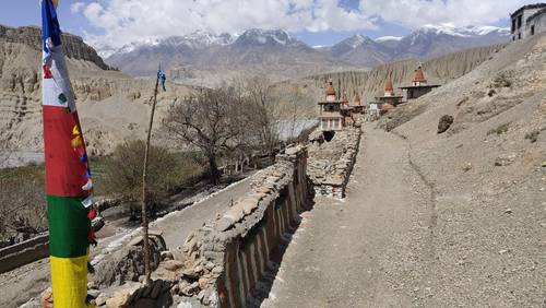
Road and jeep tracks In The Kali Gandaki Valley
The main road goes from Tibet (China) down the Kali Gandaki Valley through Lo Manthang via Jomsom to Pokhara. It would be a very unpleasant experience walking on this road as there is quite a lot of traffic throwing up dust, as buses, jeeps, and motorbikes whizz by. This is the same road that affects the Annapurna Circuit trail after crossing the Thorong La pass. In April 2024, I did a reconnaissance trek for 4 days on the Annapurna Circuit from Jomsom to Tatopani by following the East bank of the Kali Gandaki. This is a superb trail along the New Annapurna Trekking Trails (NATTs) away from the road. After this successful trek last year, I was curious to find out whether I could find similar trails away from the road in Upper Mustang.
It is worth pointing out that, these days, almost all of the villages in Upper Mustang are connected by a jeep track or a road. Of course, this is understandable as having transport to their homes makes the Mustangis' lives much easier and increases their standard of living. In practice, there is very little, if any traffic, on these jeep tracks connecting the villages. Between villages, we are able to get away from the jeep tracks by following quiet trekking trails, although sometimes we walked on the road or jeep track for the last section as we approached a village (Ghiling, Ghami, Dhakmar, Lo Manthang, and Yara).
The other point worth mentioning is that power, cell phone connectivity (Nepal Telecom is better than Ncell), and WiFi are available almost everywhere.
Researching The Remote Trails of Upper Mustang
I used the following sources to research the best trails:
- A Trekking Guide to Upper & Lower Mustang by Sian Pritchard-Jones and Bob Gibbons
- Mustang NP108 Great Himalaya Trail Series Map 1:100,000 by Himalayan Maphouse
- GPX file provided by Richard Bull showing the trail used by The Mustang Trail Race (takes place every April).
- Talking to our guide, Galden Sherpa, who had led numerous treks in Upper Mustang.
As ever, it is only possible to design an itinerary by actually walking the trail by oneself. First-hand experience is key to concluding whether the trek is worth doing and to finding the best trails. Based on my research, we planned to do a circuit of Upper Mustang by ascending on the West side of the Kali Gandaki (same side as the road) and descending on the quieter and less developed East side. In practice, we stuck to this plan, and I have described how it went in detail in the next three paragraphs.
Upper Mustang Trek Up to Lo Manthang
In total, over three days, I estimate that we walked on the main road for only about 15 or 20 minutes. We also walked on jeep tracks (with very little traffic) for about 20 minutes in total. You can read the daily description of how much walking is on trails versus roads and jeep tracks below:
Trek Day 1: Drive to Samar (3,660m), then trek to Ghiling village (3,570m) via Chungzi Caves, Shyangboche and Tamagaon
The old trekking trail for Upper Mustang starts in Kagbeni, whereas we drove further up to Samar. There are no viable trekking trails to follow, so rather than walking for two days on the road, it makes sense to drive to Samar. From here, we walk on the lovely trail to Chungzhi Caves, and after visiting this holy place, we walk up to Shyangboche, located on the road. Shortly after leaving this place, we turn left off the road at the “Trekking Trail” signpost. After ascending to a small pass with the road below us, we descend and then turn off away from the road by following the trail to the hamlet of Tamagaon. From here we descend on a trail towards Ghiling and then meet the road further downhill. After walking on the road for about 10 minutes, we turn off it to enter the village.
Trek Day 2: Trek to Dhakmar village (3,820m) via Keke La (4,030m) and Ghami (3,520m)
We take the trekking trail starting near the old Gompa on a hill above Ghiling. This is a lovely trail that traverses the hillside and is away from the road, which is far away in the valley below. After crossing the Keke La (4,030m), we descend on a trail from the pass down to the road. We immediately cross the road to the trekking trail on the other side. After crossing a small pass, we descend and follow the road for 5 minutes to Ghami village. After Ghami, we don’t touch the main road again until just before Lo Manthang. From Ghami village, we cross the river on a bridge, then ascend to a pass, and gradually descend to a jeep track, following it for 10 minutes to Dhakmar. In practice, there is very little traffic, and it is more like walking on a wide trail.
Trek Day 3: Trek to Lo Manthang (3,800m) via Lo Gekar also known as Ghar Gompa
Our day begins with a walk through the upper part of Dhakmar village, and shortly after leaving the village, we turn right off the jeep track. We ascend a dramatic gorge up to the first pass and then traverse a high-altitude plateau before ascending to the Mui La pass, which stands at 4,170 meters. Our descent leads us along a trail towards, and then we join the jeep track in places until we reach Ghar Gompa. After leaving the monastery complex, we briefly rejoin the jeep track for about five minutes before turning onto the trekking trail up to Choku La pass (4,298m). We descend following a trail and rejoin the main road just below the kani entrance to the walled City of Lo Manthang.

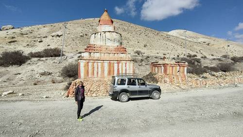
The Walled City of Lo Manthang
We stayed at the Hotel Mandala in Lo Manthang for three nights. On the first day, we explored the Walled City and visited the monasteries. On the second day, we took a jeep for a drive north of Lo Manthang to visit the Jhong Caves, Lo Nyifu, and Lo Garfu monasteries. On the way back, we drove via Thinggar village to see the summer Royal palace.
It makes sense to drive by jeep on the road north of Lo Manthang as it is too far to visit these places by walking on foot. Also, it would not be very pleasant to walk along the road as it is dusty, especially when the wind gets up.
In practice, there are not many trekkers in Upper Mustang, although these days Lo Manthang is quite busy with other visitors coming by motorcycle, jeep, and bus. When we were there, there were several Nepalese groups as they had a holiday time over the Nepalese New Year. Interestingly, after speaking to two foreign trekkers from another group, their guide had walked up Lo Manthang with them by following the road! If you are considering doing this trek with another operator, then you should double-check their proposed route. I am not sure why some guides are still walking on the road, whether they cannot read a map, or perhaps they are just being lazy!

Upper Mustang Trek Down from Lo Manthang
On the descent, we walked off the road virtually the entire way, apart from touching the road briefly at the pass, a short distance south of Lo Manthang. After this point, we cross to the East side of the Kali Gandaki, away from the road, until Tetang village. On the way to Tangge and Yara villages, we walked on a jeep track for about 10 minutes each day. On the last day from Tangge to Tetang, if the direct trail is open, then you walk on a trekking trail the whole way. If the direct trail down to Tetang is not passable, then we walk around via Chussang. If so, we descend to the road and walk on it for 5 minutes to Chussang and from there walk on a jeep track to Tetang for ½ hour.
The three days descending from Lo Manthang have a very different feel from the days ascending. The East bank of Kali Gandaki is more remote and has far fewer villages. The last day is quite long, taking between 9 and 10 hours of walking, although it is well worth it as the scenery is superb. This is probably the best day’s walk in Upper Mustang, and it is a shame that most trekkers do not walk this section!
The Highlights of Upper Mustang Trek
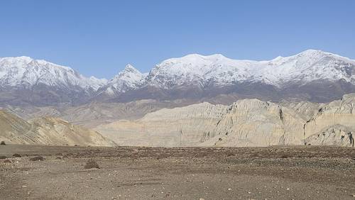
- Incredible landscape characterized by dramatic valleys, red hills, and arid desert-like conditions. Upper Mustang's mystical caves, also known as Sky Caves, are carved into the cliffs and valley walls.
- The peace and quiet. During our reconnaissance trek in April 2025, we were amazed to encounter only two other trekkers during eight days of walking on these trails. It felt like we had this magical place almost entirely to ourselves.
- We are delighted to report that the vast majority of our route was along trails, away from the dusty road from Jomsom to Lo Manthang.
- For two nights on the way up to Lo Manthang and for two nights on the way down, we stay in lodges, mostly housed within traditional-style buildings. This is a good way of interacting with the local community, as we usually sit and spend time with the host family in their kitchen.
- In Lo Manthang, we have selected Hotel Mandala as the best one to use for our groups. This is a newer hotel with more modern facilities than some of the older lodges. It has a lovely inner courtyard with the Mendho cafe, which will be popular if you like a decent coffee, juice, or milkshake (lassi). This hotel is conveniently located only a short walk from the walled city, so it is a comfortable base to explore Lo Manthang.
Conclusion
Our reconnaissance trek through Upper Mustang in April 2025 definitively answers YES to the question: Can You Still Escape the Road? While the introduction of the motorable road has undeniably altered the region, it has not diminished the opportunity for an exceptional trekking experience. In fact, our exploration revealed that approximately 95% of a well-planned route can still follow original, remote trails, far removed from the dust and traffic of the main road.
The stark and majestic landscapes, characterized by dramatic valleys and the iconic red cliffs, remain as captivating as ever. The chance to discover the ancient Sky Caves adds a unique layer of mystique and historical intrigue to the journey. Perhaps most surprisingly, the tranquility and solitude found on these less-trodden paths were quite remarkable. Encountering only two other trekkers over eight days of walking underscored the feeling of having this extraordinary region almost entirely to ourselves.
The shift towards lodge-based accommodation has also proven to be a positive development. Not only is it a more cost-effective option compared to fully supported camping treks, but it also provides invaluable opportunities for genuine cultural exchange with the local host families. And while Lo Manthang has certainly become a hub for various types of travellers, the ancient Walled City itself still offers a fascinating glimpse into a rich cultural heritage.
For those seeking an authentic and relatively short trekking adventure in Nepal that blends stunning natural beauty with cultural immersion and a welcome degree of remoteness, Upper Mustang continues to deliver. By carefully selecting a route that prioritises the original trails, as detailed in our Upper Mustang Circuit trek itinerary, it is entirely possible to bypass the majority of the road and discover the true spirit of this remarkable region. Don't let the presence of a road deter you; the heart of Upper Mustang's trekking allure remains very much alive and waiting to be explored.
We organise several trekking itineraries that explore the Upper Mustang region in Nepal:
Upper Mustang Circuit
Naar to Upper Mustang GHT
Saribung Expedition
Upper Dolpo to Jomsom GHT
If you would like any more information about Upper Mustang or would like to join one of our groups, then please get in touch.
Roland Hunter
The Mountain Company