
Nanga Parbat Circuit & Mazeno La
Pakistan
5 Based On 4 Reviews
9 Trees Planted for each Booking
Details
Our Nanga Parbat Circuit itinerary is based on our first-hand experience of organising this trek in Pakistan. In June 2025, we had a group successfully complete this trek, and in June 2022, we did a reconnaissance trek. This is a challenging trail that is rarely trekked by other groups, unlike the busier K2 Base Camp trek.
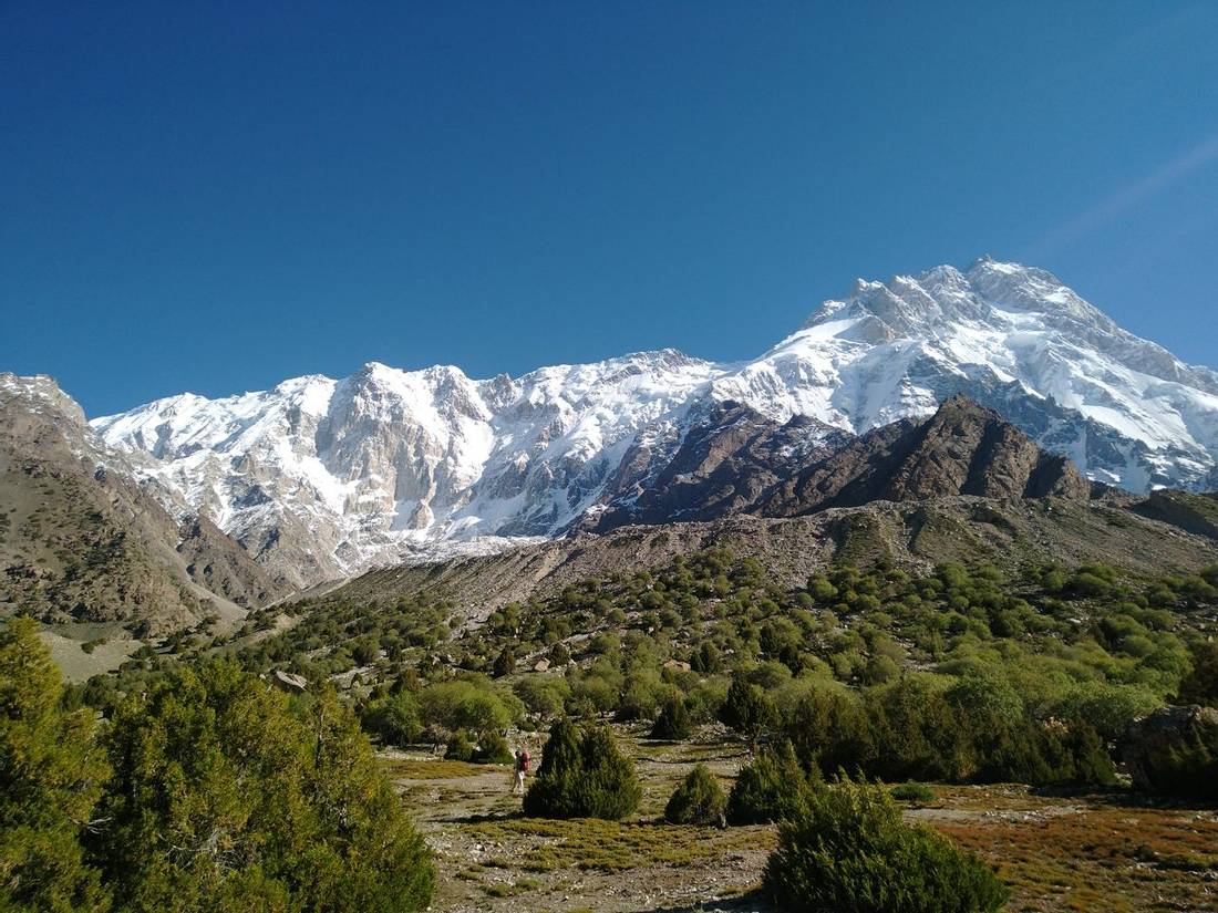
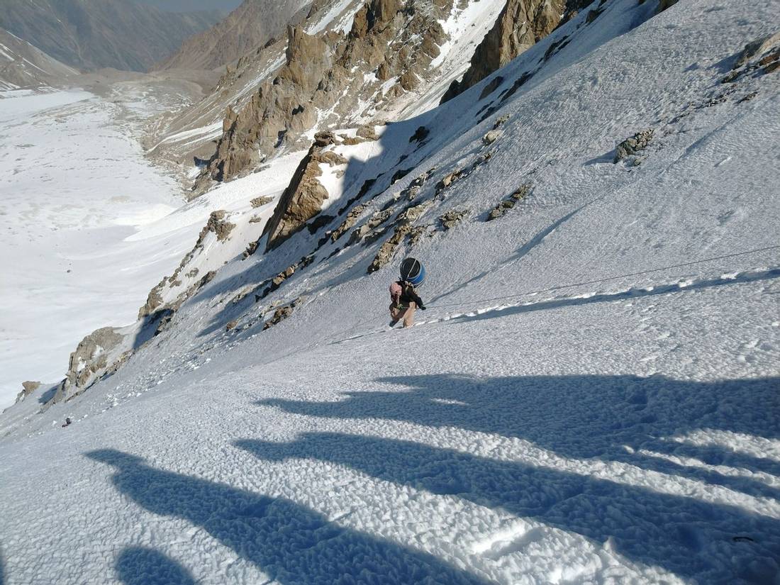
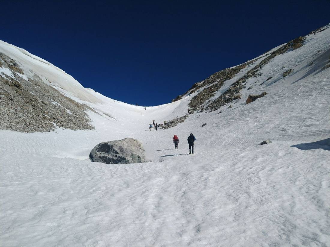
Nanga Parbat Circuit trek in Pakistan, Karakoram is a remote trail around the 9th-highest mountain in the world. We cross the Mazeno La at 5,400m, which is a technical high pass where you need mountaineering skills to safely cross. The difficulty grade of crossing Mazeno La is like crossing Gondogoro La on the K2 Base Camp trek. The ascent to this pass is on a glacier with snow and ice. The more challenging part of crossing Mazeno La is on the descent. As it is quite steep, we abseil/rappel down a fixed rope to secure our passage.
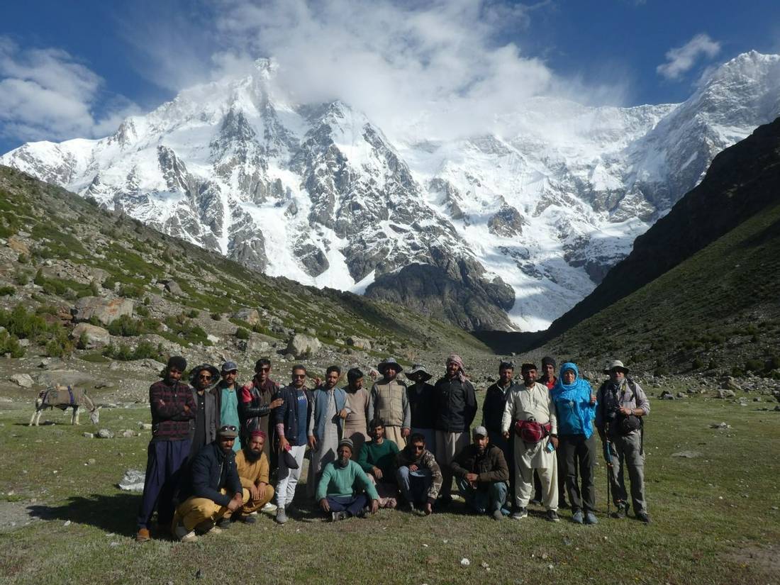
We visit the three Base Camps used for climbing the three faces of Nanga Parbat. These are the Herligkoffer Base Camp for Rupal Face, Diamir Base Camp, and Raikhot Base Camp near Fairy Meadows. Take a look at Piotr's superb video from his Nanga Parbat Circuit trek with Ade in 2022.
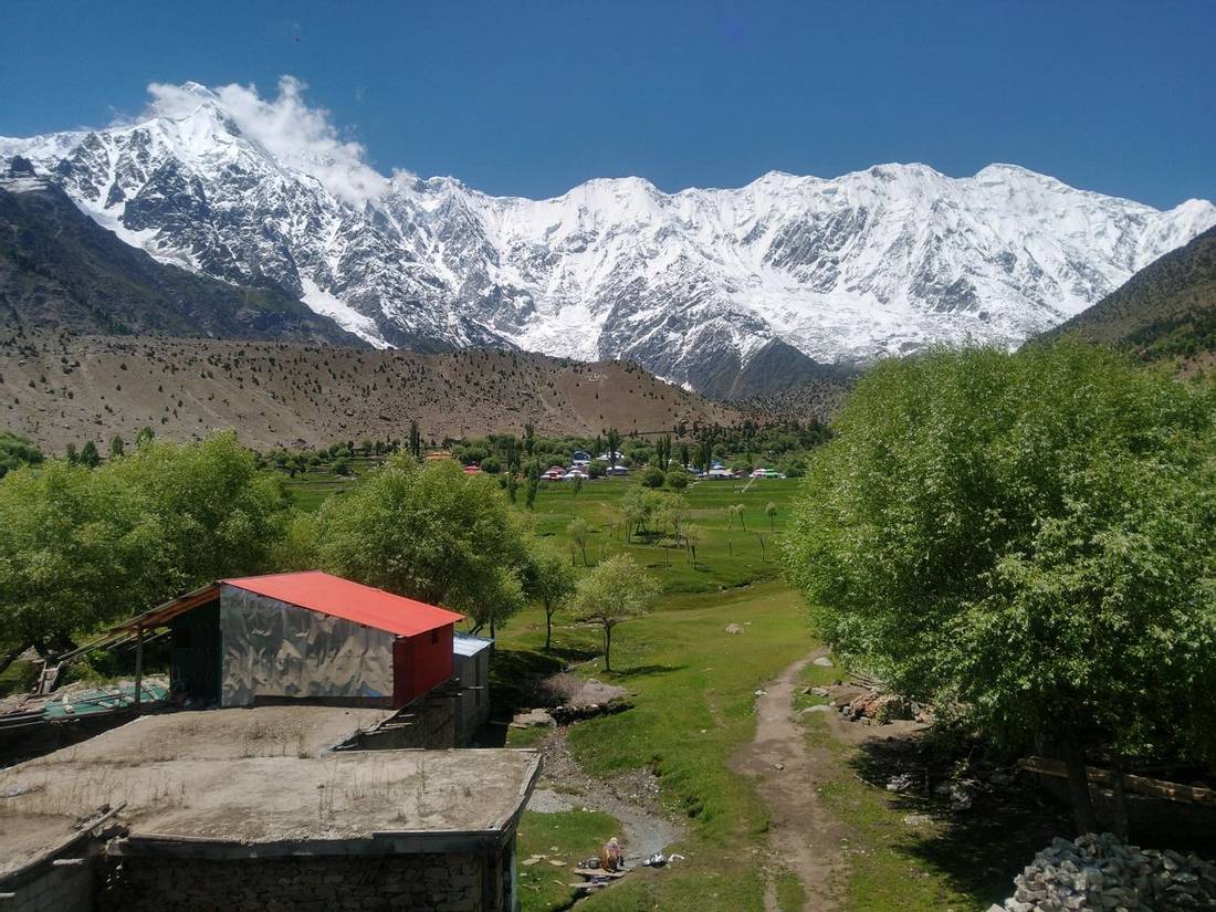
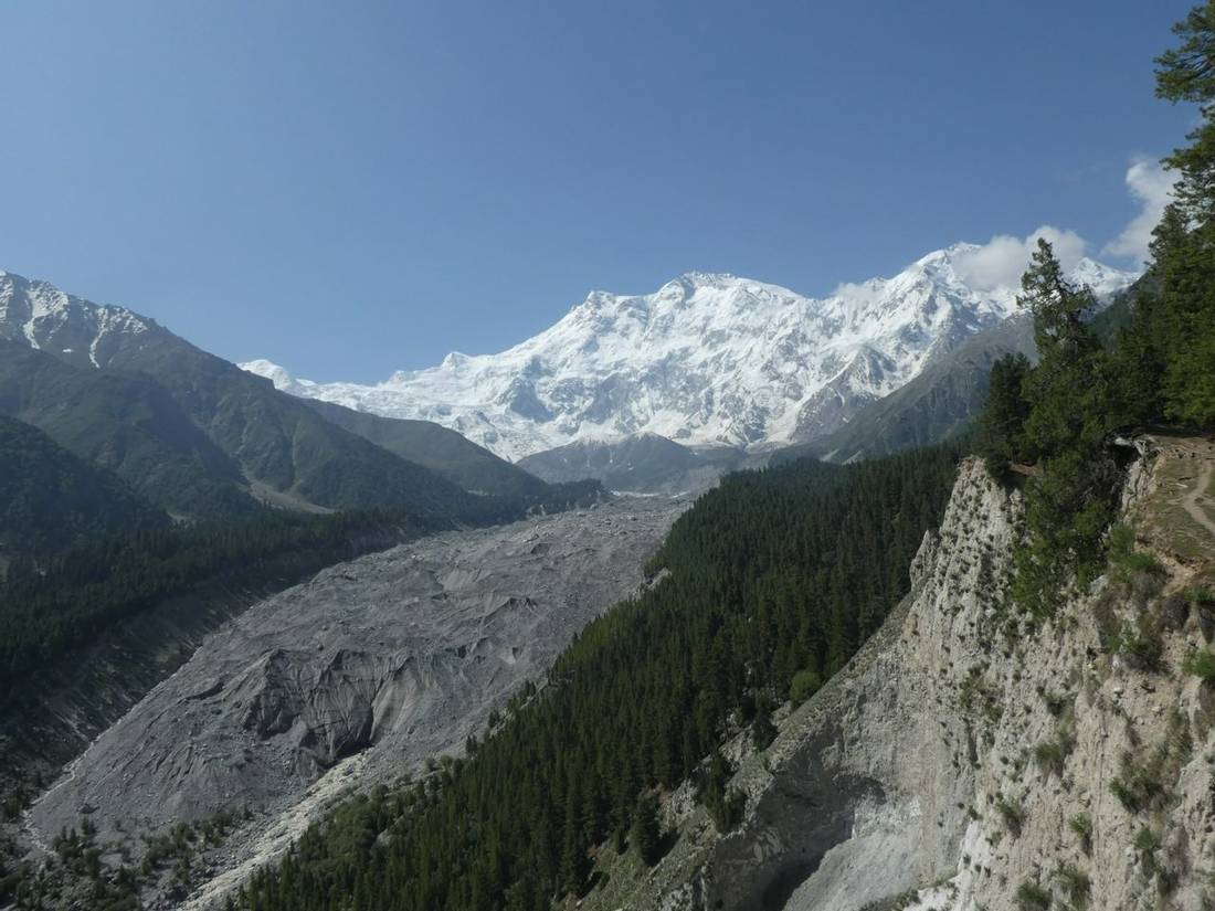
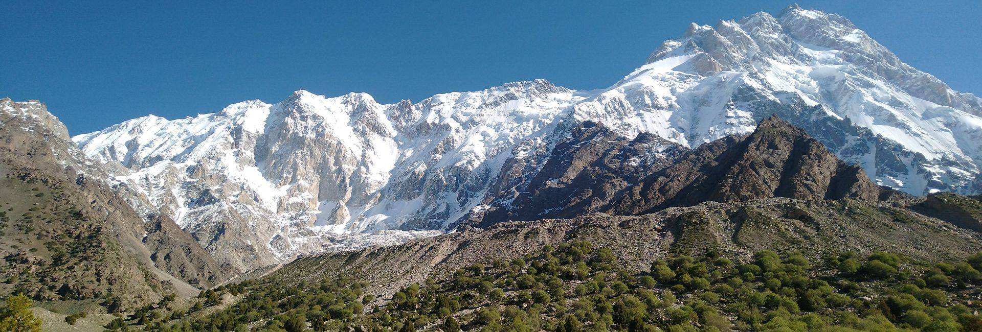
Translated from Urdu, the words Nanga Parbat means "Naked Mountain". The summit of this mountain is at an altitude of 8,126m. It is the second most prominent peak of the Himalayas after Mount Everest. This mountain is an isolated massif, and its location is south of the great peaks of the Karakoram. A distance of 190km to the North-East lies K2, Broad Peak, and Gasherbrum 1 and 2. We can see the bulk of Nanga Parbat from the Karakoram Highway (“KKH”) beyond the town of Chilas.
Nanga Parbat has a long, colourful, and deadly mountaineering history. Before the Second World War, there were several German expeditions resulting in 31 deaths. As a result, this peak was called the “Killer Mountain”. These early expeditions approached from the north. This route is prone to avalanches and bad weather.
The first ascent was by Herman Buhl in 1953 on the Rakhiot Flank to the East of the mountain. Herman climbed solo and without supplemental oxygen. This was the third summit of an 8,000m mountain after Annapurna 1 in 1950 and Mount Everest in 1953. These days, most expeditions climb on the Diamir face following the Kinshofer Route.
A prominent feature of this mountain is the Mazeno Ridge. This is the longest ridge on any of the 8,000m peaks, and there are seven subsidiary peaks over 7,000m. This ridge starts from the Mazeno La, which we cross over on the Nanga Parbat Circuit trek. Climbing to the summit of Nanga Parbat following the Mazeno ridge is very difficult. There have been many attempts, including three times by Doug Scott. The ridge was first climbed to the summit in 2012 by Sandy Allan and Rick Allen.
- We are Karakoram trekking specialists, having operated trips in Pakistan since 2004. Roland Hunter has designed the itinerary based on Ade Summer's reconnaissance trek to Nanga Parbat in June 2022 and updated after our group in June 2025 (for changes, please read our Trip Report for Nanga Parbat Circuit in June 2025 led by Ade Summers).
- We work with some of the best mountain leaders with deep knowledge of trekking in the Karakoram. Unlike many other operators, we use trained international leaders for this trip.
- We have included a gradual ascent profile in our itinerary for this trekking holiday. This will help you acclimatise to the high altitude.
- Based on client feedback, we won the 2018 Gold Award as AITO Tour Operator of the Year. Read more about our Testimonials and Awards.
- We review weather forecasts in the Nanga Parbat region throughout the duration of this trek.
- We send a Thuraya satellite phone on our group treks in Pakistan. Your leader will have reliable communications for logistics, planning, and group safety. We use GPS to upload your location daily onto Google Maps to track your progress during the trek.
- We provide a range of tasty meals for breakfast, lunch, and supper. For breakfast, we provide fresh coffee from our Bialetti Moka coffee machine.
- We bring a comprehensive medical aid kit. There will also be a portable altitude chamber (PAC or Gamow bag).
- Our team, with first-hand knowledge of this trek, provides pre-trip support.
Route Map
Itinerary
We meet you on arrival at Islamabad airport and drive to the hotel. At some point during the day, your leader will give the trek briefing and check your gear. The rest of the day is free to explore Islamabad and pack your bags.
This morning we take the PIA flight to Skardu and then drive to Gilgit (1,500m). If there is a cancellation of this flight, then we will drive the Karakoram Highway (“KKH”) to Naran. If we have time, then we will continue over the Babusar pass (4,173m) to Chilas.
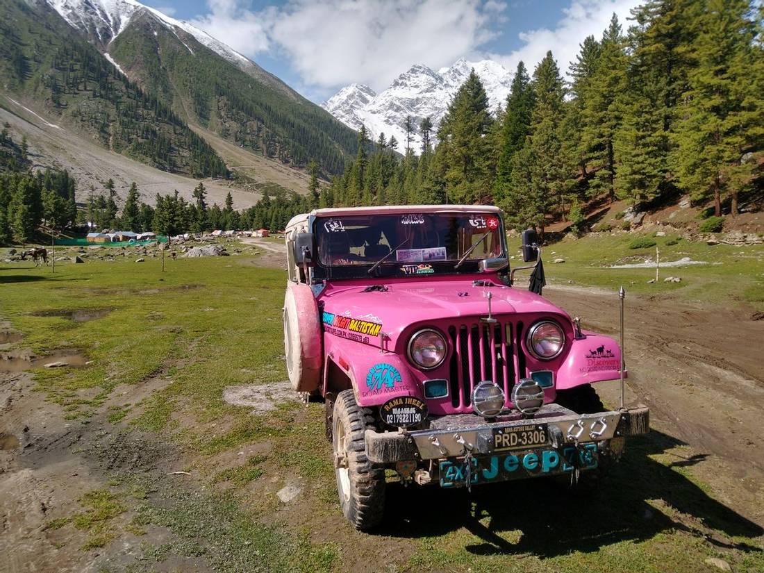
We drive the KKH to Raikot Bridge, taking about 1 1/2 hours, where we stop for lunch. From here, we change jeeps and follow the mountain road to near Fairy Meadows. This drive takes about another 2 hours. There are spectacular views of Nanga Parbat and Rakaposhi down the valley. We stay in a guest house at Fairy Meadows.
Today, we explore the area around Fairy Meadows and enjoy the views of Nanga Parbat. This is also an important acclimatisation day before going up to higher altitudes.
We leave Fairy Meadows for a walk through the pine forest to the campsite at Beyal, taking about 1 1/2 hours. For the rest of the day, we can explore the area and enjoy being in this lovely place.
After breakfast, we head off for the walk to Riakot Base Camp. Along the way, we have great views up and down the valley. After arriving back at Beyal, we walk back to Fairy Meadows, which is an easy 1-hour walk.
We drive by jeep to Raikot Bridge, then switch vehicles for the drive to the town of Astore (2,350m).
After a night in Astore, we drive to Tarashing (2,920m). In the afternoon, we will go for a hike around Tarashing.
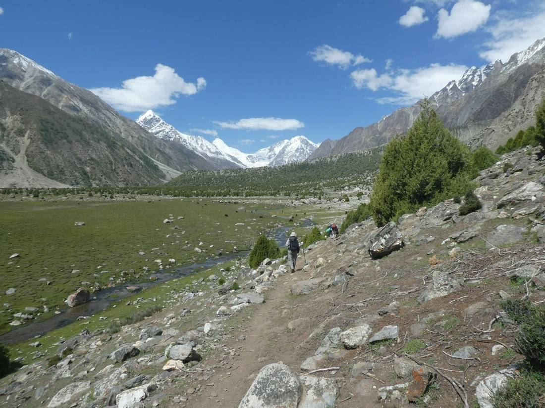
Today we start the trek around Nanga Parbat. Leaving Tarashing we follow a good trail and easy climb up to the moraine. We descend to the glacier and cross on a marked trail. Once across we head to the green fields and tree-lined water channels. After following the valley for about 2 hours we get to lower Rupal. A further ½ hour brings us to the Upper Rupal campsite with amazing views of the Rupal face of Nanga Parbat and Riakot peak. After lunch we continue along the valley on a good trail and then follow the lateral moraine to Herligkoffer Base Camp. This takes about 2 1/2 hours of walking.
Staying two nights at Herligkoffer Base Camp (3,600m) helps with our acclimatisation to the high altitude. We will explore the area around Herligkoffer Base Camp as it is a spectacular place. For our morning’s walk, we head up the valley to the end of the moraine at an altitude of 3,750m. We get a great view of the glacier coming off Nanga Parbat. In the afternoon, we relax at the camp while soaking up the impressive location.
From Camp, we have an easy climb up the moraine and then follow a trail down to the glacier. It takes an hour to cross to the other side and then there is a short climb over the far moraine. This takes about 1 ½ hours. After ½ hour we reach a large open valley. Following this valley, for ½ hour we take a detour up to the terminal moraine of a side glacier and up to a lake. This is a spectacular place and worth resting to enjoy the amazing views.
We continue around the edge of the lake and then cross the outflow river by hopping over rocks. We descend down off the moraine and to the open grasslands which lead to the Base Camp called Latobah. We stop for lunch at a few buildings belonging to the local shepherds.
After a good rest, we continue by following the valley for about 2 hours. If a sunny day, it will be hot in the afternoon with not many places to get shade. After about 1 ½ hours we see a square house-size rock (Shaigiri or White Stone). Our Camp is about 20 minutes past this rock in a river gully with shade and clean water.
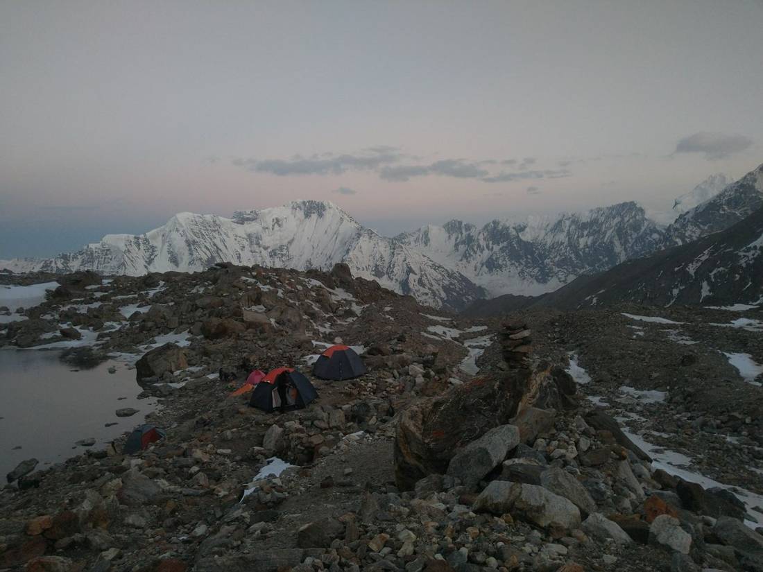
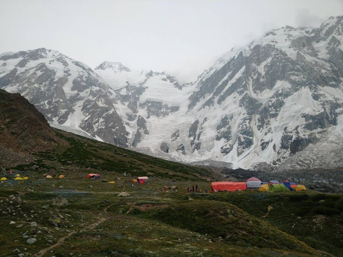
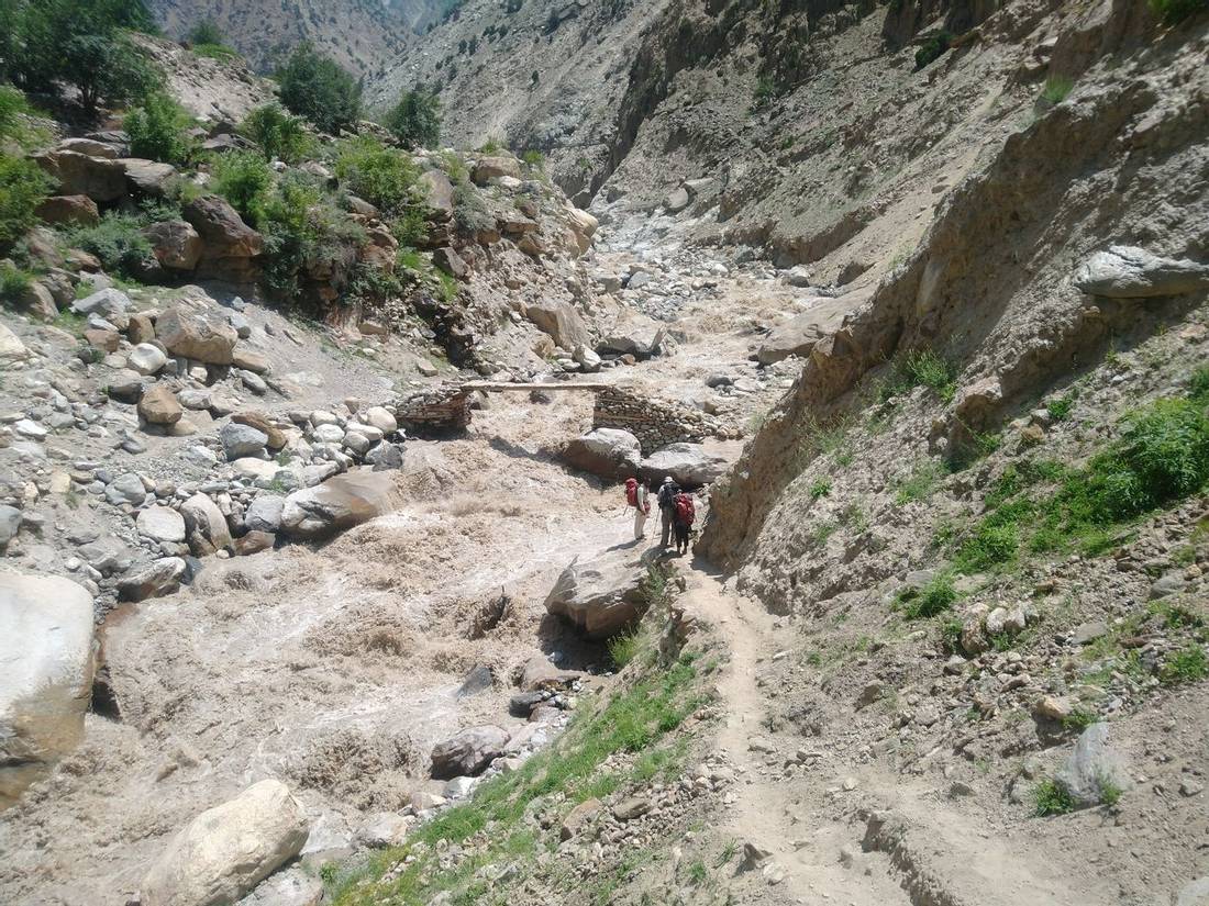
We leave the camp by ascending the moraine and following the valley to gradually gain altitude. We pass a shepherd's hut made like a tipi which is a nice shady place to rest. We continue along the valley and onto the moraine of the Bizin glacier. There are two river crossings on the way, but usually, these can by easily crossed by hopping over the rocks. As the moraine ends and the Mazeno La Base Camp comes into sight. After the end of the moraine and we have a descent on sand to about halfway to the glacier. Then we have a tricky rocky traverse to the campsite. Mazeno La Base Camp (4,060m) is located on a beautiful grassy meadow in a hanging valley that leads to the Mazeno La.
Staying two nights at Mazeno Base Camp (4,060m) helps with our acclimatisation to the high altitude. After breakfast, we head off for an acclimisation walk where we reach 4,360m which takes about 2 ½ hours. We walk up the moraine ridge behind Camp before gaining the shoulder. From there we follow a good trail heading up and to the right. There are amazing views of the Bizin glacier and Laila peak in the shadow of the Mazeno Ridge.
We get back to camp for lunch. In the afternoon we have a training session for the skills required to cross the Mazeno La. We will rig up a fixed line to practice abseiling (rappelling) and prussiking skills.
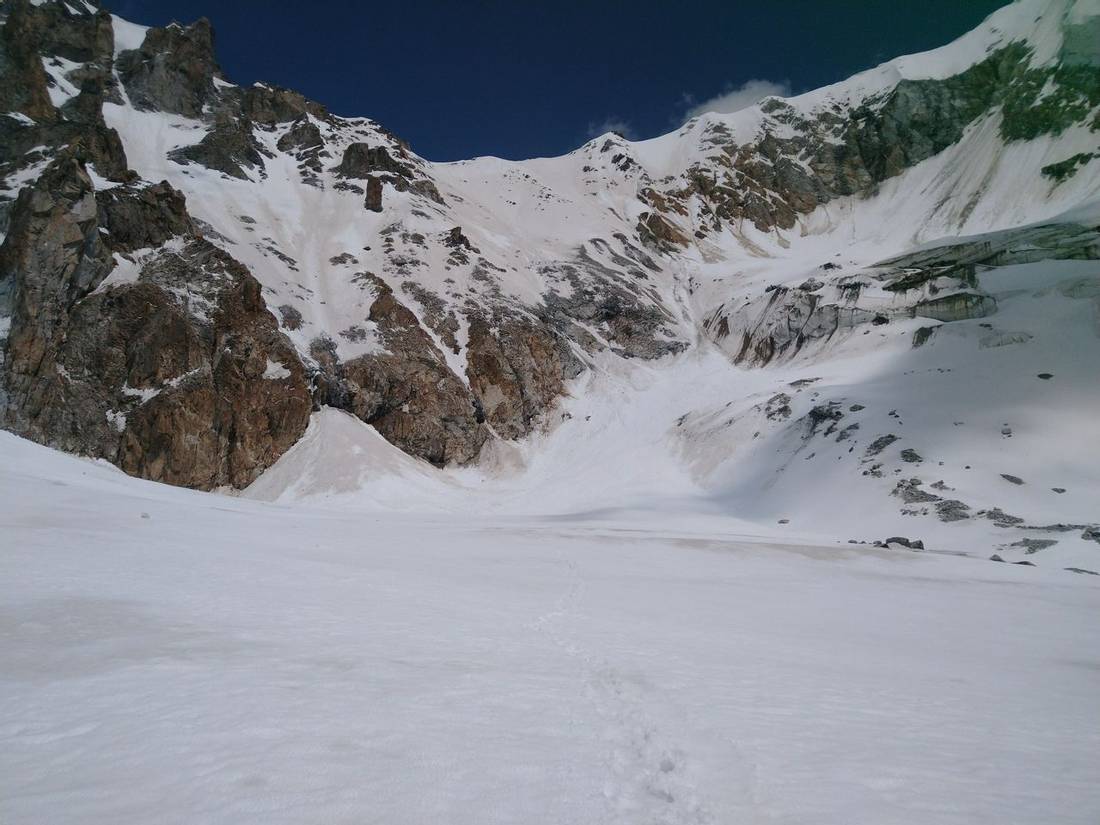
We leave camp by retracing our morning walk from yesterday. The trail follows around to the right heading towards where the grey glacial moraine meets the upper valley wall.. As we gain height the trail becomes rockier and less defined. After about 2 ½ hours we reach a rough camp known as Mazeno La lower High Camp. After here the trail gets harder to follow but there are stone cairn markers. Next, we need to cross three pressure ridges and head for a car size rock on the third ridge. After the large rock, you are about 30-45 minutes from Mazeno High Camp. Often there are some snowfields to cross. After a few scrambly and tricky sections we arrive at Mazeno High Camp at an altitude of 4,865m.
We will get up for an early breakfast and plan to leave High Camp at 3.30am. The trail out of camp starts off quite easy going and we can almost see the pass. We ascend the ridge behind High Camp and then come around to the left to pick up the obvious ridge that leads to the pass.
There are a few scrambly snow field sections to negoiate and then drop down to cross a small crevase. We go slightly to the left to pick up the main ridge that leads to the pass. Once we gain this ridge we have a steady walk up to the pass apart from a few loose sections with a zig zag path. There will be snow for the last section however the porters put in a trail for the group to follow in their footsteps. It takes about 4 hours of walking from High Camp to the pass.
At the summit of the Mazeno La, there are amazing views down both sides of the pass. It is narrow on the top, so care is needed. We will gear up putting on crampons, harness, and helmet ready for the descent. While we are doing this, the porters start to lower their loads. The porters will start carrying their loads about half way on a rocky outcrop when the route turn hard left and down a gully to reach the valley floor. We will follow the porters on the fix line using a safety and prussic technique practiced on our training day at Mazeno La Base Camp. We descend fixed rope past the rocky outcrop and to the valley floor. From there we walk down the glacier and after ½ hour stop on a rock section to have a rest.
We continue down the glacier for 1 hour then cross a loose rubbly area. It is a further 1 ½ hours to reach Upper Loiba a grassy meadow next to a river. This is a long and hard day at a high altitude but Mazeno La is a really amazing pass to cross. We have dinner and then early to bed.
We have a later start after the big day crossing the pass yesterday. Our group in 2025 opted to walk down to Lower Loiba rather than spend two nights at Upper Loiba in order to benefit from more oxygen nearly 1,000m lower down. After leaving Upper Loiba, we cross over a few rocky sections to get off the moraine and then follow a beautiful trail to the valley below. Soon after, we arrive at the campsite at Lower Loiba.
We follow the trail through the forest contouring around a few gullies. We gain 200m of altitude around a ridge and then start the descent. From here is down down down about 1,200m on a loose and dusty trail. After about 3 hours, we arrive at the oasis settlement of Jhal. It is a good place to rest in the shade, and if you are lucky, you might be invited into a local house for tea. After a good rest, we descend to the river through fields of wheat and potatoes, before crossing a short bridge over the river. The trail gets much better after joining the main one to Nanga Parbat Diamer Base Camp. After 1 ½ hours, we arrive at the beautiful terrace fields of Ser and walk through the village. We set up camp in the school’s playing field. This school was funded by Reinhold Messner in memory of his brother, Gunther, who died while climbing on Nanga Parbat.
Shortly on leaving the village we walk through a steep rocky section of a gorge gaining about 200m in altitude. After this, the trail is easier along the valley shoulder. After a further 2 hours, we arrive at Kachal where we stop for tea. After a few more hours walking through shaded trees, we gain the moraine of the main valley. We are heading for the big rock ridge. Amazing views of Nanga Parbat start to appear. Once around the rock ridge, there is a rocky and sandy moraine section that leads you to the summer pastures of Kutgali with a number of stone houses. It is only 15 minutes further until the stone house is constructed by donations from Reinhold Messner. Kutgali is a wonderful campsite with full views of Nanga Parbat.
It is an easy 2-hour walk to Diamer Base Camp. It is beautifully located in a grassy meadow just before the glacier that leads up to the mountain. We spend some time meeting the expedition teams and visiting the memorial plaques. It takes just over an hour to walk back to Kutgali.
We retrace our steps down the valley and after 2 hours get to Kachal. After another 2 hours, we reach Ser and the school where we stayed on the way up.
After Ser, we walk on a bridge over the raging water in the river below. The trail to the settlement of Jhal is tricky in places where sections have slipped away. After about an hour we have a steep descent to the river and a short climb up to the village of Jhal where we stop for lunch. After a rest, we continue down the valley on a good trail following a water channel. After 3 ½ hours of walking, we arrive at Diamaroi village.
We head off down an easy trail for 45 minutes to the junction of the rivers. As there is no bridge the only way to cross the river is using a “jhola”. This is the classic Pakistan wire and box crossing. Once over the river, we load up the jeeps for the drive on the jeep track down to the Karakoram Highway (“KKH”). After joining the KKH we drive to Raikot Bridge where we stop for lunch. From here we change jeeps and follow the mountain road to Tato. This drive takes about 1 ½ hours. After arriving at Tato we walk for 3 hours to Fairy Meadows. This is an easy walk on a good trail with spectacular views of Nanga Parbat and Rakaposhi down the valley. We stay in a guest house at Fairy Meadows.
We have an early start and follow the road up to the Babusar Pass (4,173m). We descend to Naran and then drive onto Islamabad.
Today we will spend the day in Islamabad. In the evening we have a group meal to celebrate our journey in the Karakoram mountains of Pakistan.
Transfer to airport for flight home. End of trip.
Dates & Prices
We provide an early bird discount for the first people paying their deposits to make up our minimum group size
2027
| Dates | Trip Leader | Price | Single Supplement: Room/Tent | Availability | |
|---|---|---|---|---|---|
| Dates 02 Jun 2027 to 27 Jun 2027 | Trip Leader International Leader |
Price
US$5,395pp US$5,195pp |
Single Supplement: Room/Tent US$550pp / US$495pp |
Availability
5 Left to Guarantee Early Bird Discount |
Book Now |
2028
| Dates | Trip Leader | Price | Single Supplement: Room/Tent | Availability | |
|---|---|---|---|---|---|
| Dates 07 Jun 2028 to 02 Jul 2028 | Trip Leader International Leader |
Price
US$5,495pp US$5,295pp |
Single Supplement: Room/Tent US$550pp / US$495pp |
Availability
5 Left to Guarantee Early Bird Discount |
Book Now |
For private and bespoke trip, please contact us
Enquire HereWhat's Included
- Internal flights from Islamabad to Gilgit. If cancelled then we will drive on Karakoram Highway.
- All internal transport and transfers including airport collections for group flights only.
- Twin-share rooms at hotels.
- Breakfast only in Islamabad, all meals included in Gilgit and while on the trek.
- Twin share tents while on the trek. These are domed tents with plenty of space for two people sharing plus gear.
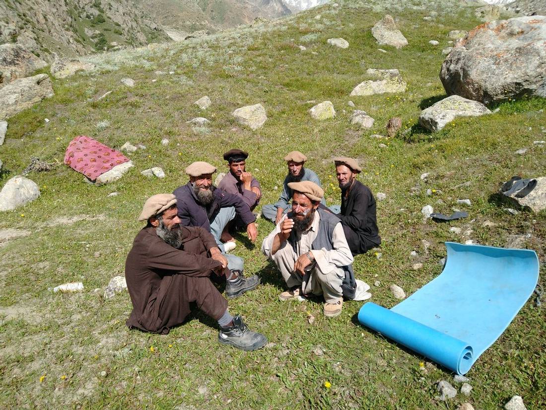
- Trekking arrangements. Including permits and fees, tents, International and Pakistan guides, porters, and cooks.
- Porters to carry your main bag. The porterage allowance is 18kg.
- Weather forecasts for the Nanga Parbat region during your trek.
- Thuraya satellite phone for organising logistics and medical evacuations. It can also be also used for personal calls at extra cost.
- Portable high altitude chamber (PAC bag) and expedition medical kit.
- GPS tracking on Google Maps. Your friends and family can track your progress during the trek.
- UK-registered charity, Pipal Tree, will plant 9 trees for you in the Gurkha Memorial Forest in southern Nepal.
- Full financial protection for bookings from the UK (ATOL) and internationally (ABTOT). Our Air Travel Organiser’s Licence (ATOL) number is 10921. Our Association of Bonded Travel Operators Trust (ABTOT) membership number is 5365).
- Pre-departure support and advice from The Mountain Company. We are available by email, phone, or face-to-face meetings
What's Not Included
- International flight to/from Islamabad.
- Travel & trekking insurance.
- Pakistan visa for 30 days.
- Lunch and evening meals in Islamabad.
- Personal clothing & equipment, please see Practical Information for kit list.
- Tips to the trek crew. Each trekker should budget for giving tips into the group fund. This should be in the region of £140 or US$175.
- Other items not listed in “What is included”.
Accommodation
Hill View Hotel in Islamabad
Hotel Hill View is a modern hotel and is a comfortable base for our groups while in Islamabad. It is a short walk to Jinnah market where there are good restaurants and shops. There is wifi at the hotel.
Practical Information
A Typical Day On Camping Trek in Pakistan
We provide a comfortable experience on our camping style treks in Pakistan. Our team works hard to support you so that you can relax and enjoy the trek. We provide personal tents, mess tent, kitchen tent and toilet tent(s). The camp will be set up and dismantled by the trek crew. We bring along a cook and kitchen helpers to provide the meals.
The day starts with an early morning mug of tea in the mess tent. Before breakfast you pack your overnight gear into your duffel bag. During breakfast the trek crew pack away the tents. The porters arrange their loads and set off on the trail in the cool of the morning. After breakfast, between 7am and 8am, we start walking.
The pace of the trek is moderate as there is plenty of time in the itinerary to reach the camp for tonight. There will be plenty of time to enjoy the scenery, take photos and explore the local villages. Lunch will be around midday at a spot by the side of the trail. Our cooks prepare lunch for us and the food is usually ready by the time the group arrives.
After lunch we continue the walk and on most days we arrive to camp by mid afternoon. Some of the trek crew would have gone ahead of the group to set up camp and to put up the tents. On arrival to camp you will get a hot drink and biscuits. In the evening our cook will provide a three course meal in the mess tent around 6pm.
After supper the leaders will discuss the plan for the next day. Afterwards people might stay in the mess tent chatting about the day’s events or playing cards. After a tiring day most people head to their tent quite early for the night. Tomorrow is likely to be very similar as today! The only difference is that if we are crossing a high pass or climbing to a summit we leave camp earlier in the morning.
Food provided on Camping Trek in Pakistan
While on a camping style trek in Pakistan we provide tasty and nutritional food. We make sure there is more than enough quantity to go around as trekkers will be hungry after a long day on the trail. Over the years we have worked on increasing the variety of the menus. We have expanded the list of ingredients provided to the cooks so they have more to work with.
For breakfast we provide porridge or cereal, toast or chapatis and eggs. There will be hot drinks including tea, hot chocolate and coffee. We provide fresh coffee from our Bialetti Moka coffee machine.
For lunch we stop at a convenient spot with water at the side of the trail. The cook and kitchen walk ahead of the group in the morning and lunch should be ready shortly after our arrival. After lunch we have time to relax before starting to walk again in the afternoon.
On arrival at camp in the afternoon you have biscuits and a hot drink such as tea or coffee. Around 6pm we serve a three course meal in the mess tent. The starter is often soup with popcorn or poppadoms. We have a range of main dishes and carbohydrates including rice, potatoes or pasta. Most meals are also served with delicious flat breads made fresh by the cooks.
We cater for a variety of dietary requirements. Our meals are suitable for vegetarians. If there is a meat dish then we also provide vegetarian options as standard. During booking we find out if you have any dietary needs and agree upon meal plans before departure. If you have any questions about the food provided please get in touch with us to discuss further.
Communications
We bring a Thuraya satellite phone for logistical, safety and personal use. Personal calls charged at £4 (US$5 or €4.50) per minute and £2 (US$3 €4.50) to send and receive SMS text.
Kit list for Nanga Parbat Circuit
This is the mandatory kit list for the safety of everyone in the group and to ensure a successful trek. You must have the following items tailored for the Nanga Parbat Circuit trek. The group leader will check your gear in Islamabad before departure for the trek.
As a reminder, the weather on this trek will vary from season to season and day to day as you ascend to higher elevations. At the start of the trek, you will experience very hot conditions with temperatures up to 40 Celsius. You experience the coldest temperatures in Mazeno La High Camp at an altitude of 4,865m. Overnight lows here will be down to around -8 Celsius.
You should bring a rucsac or backpack for the gear required during the day. Your pack should contain items such as warm clothes, a jacket, a camera, water bottles, a personal first aid kit and snacks. The weight limit is 5kg. A porter will carry the rest of your personal equipment, packed in a duffel or kit bag. The weight limit for your duffel bag is 18kg. Please mark your bag on the outside for easy identification.
Print the kit list and tick items off as you pack them, then weigh your kit bag before you come on trek.
Footwear
- B1+ rated mountaineering boots. A pair of water-repellent boots with ankle support. Boots must be in good condition; the best approach is to get new boots and break them in before the trek. Over the years, we have had several boots fall apart, so you should also bring trail shoes as a backup.
- Trail shoes. Used around camp and as a backup.
- Sandals. Enclosed sandals are best to protect your feet during river crossings. Required for river crossings as well as two trekking poles.
- Walking socks.
Clothing
- Waterproof and Windproof jacket (with hood) and trousers (Gore-Tex or similar). For use if it rains or snows during the trek and in windy conditions.
- Trekking trousers.
- Soft Shell Trousers.
- Long-sleeved tops or shirts (not cotton).
- Micro fleece.
- Mid to heavyweight fleece or synthetic/ primaloft top.
- Sleeveless/ gilet or body warmer type fleece / synthetic top. This will help keep your core warm while not bulking when layering up. A gilet is used in combination with base layers, other fleeces and a down jacket. This provides the most warmth and insulation.
- Thermals or base layer for top & bottom (merino wool or synthetic).
- Medium-weight down jacket.
Head and Gloves
- Fleece gloves.
- Mountaineering gloves
- Wool or fleece hat.
- Sun hat.
- Bandana or scarf (eg. Buff Headwear).
- Head torch. Bring extra batteries.
- Sunglasses. They should have side protection or a wraparound design.
For walking on the glacier
- Trekking poles. Two poles are mandatory for your safety. These will be helpful on steep sections of the trail and river crossings. Also for walking on snow or ice higher up.
- Gaiters. A pair of shin-high gaiters is used to keep boots dry if walking through snow or on wet ground.
Climbing equipment for Mazeno La
- Climbing harness. Plus two 60cm slings, four screw gate carabiners, Figure 8 belay device and 3m of 5mm static cord for prusiks.
- C1 crampons. Universal crampons that you can use with trekking boots. Such as Stubai Universals or Kahtoola KTS crampons.
- Mountaineering ice axe with leash.
- Climbing helmet (mandatory as there is a risk of rockfall on the Mazeno La).
Personal equipment
- Sleeping bag. Overnight lows down to -8 Celsius.
- Fleece or silk liner for your sleeping bag. A liner protects your sleeping bag from getting dirty. Also helps by adding extra insulation to keep you warm at night.
- Sleeping mat (eg.Thermarest).
- Day pack. The recommended size is around 40 litres. You need to have enough space to carry water bottles, a camera, snacks, extra clothing and climbing gear. The pack should have a good waist belt. It is also a good idea to bring a rain cover to keep the contents dry.
- Stuff sacks for keeping your gear dry and organised. Or even better, are fold dry bags such as from Exped.
- Two water bottles. Nalgene wide-mouth bottles are the best.
- Pee bottle. Recommended as it means you do not have to get up to find the toilet tent at night! For men, you can use an old water bottle. For women, take a look at SheWee.
- Sunscreen and lip salve with a high SPF.
- Water purification tablets with chlorine dioxide. This kills bacteria, viruses, and cysts, including Giardia and Cryptosporidium, without leaving any residual taste, odour, or colour.
- Favourite snack food.
- Books and cards etc.
- Camera with spare batteries and memory cards.
- Solar panel and battery bank. For use to recharge devices on the remote sections of the trek.
- Insurance certificate.
- Earplugs (optional).
- Baby wipes (optional).
- Hand sanitizer. Keep this in your day pack for use after a toilet break during the trek or before eating any snacks. We provide sanitizer for use before meals.
Travelling
- Duffel bag for your personal gear on the trek. A porter will carry your bag. Rugged and waterproof, made of a plastic material. Size 100-120 litres. Eg. Mountain Equipment 100l or Rab 120l. Bring a small combination padlock to secure the bag.
- Travel clothes. You will need casual clothing for air travel days and the time spent in Islamabad and Skardu.
- Toiletry bag with soap, travel towel, toothbrush etc. We provide toilet paper while on trek.
Personal first aid kit
We provide a comprehensive group first aid kit. Please bring personal medications and other items you might use, such as:
- Any personal medications.
- Blister treatment (Compeed patches are the best)
- Rehydration powder (eg Dioralyte).
- Analgesics (paracetamol, ibuprofen and aspirin).
- Plasters and zinc oxide tape.
- Throat lozenges.
- Diamox (helps with acclimatisation).
Risk assessment for Nanga Parbat Circuit
You should be aware trekking in a developing country like Pakistan involves a risk of personal injury or death. You must accept these risks and be responsible for your own actions and involvement. Adventure travel requires an open and flexible attitude. You may experience extreme conditions and unpredictable weather. There could be last-minute changes to the itinerary beyond our control. The ability to work in a team is an important aspect of our trips.
We have performed a threat and risk assessment for our Nanga Parbat Circuit trek. Our trips have a degree of risk. This is part of the attraction of adventure travel and why so many people choose to join this type of holiday. By identifying the hazards we assess the level of risk. We have control measures in place to reduce this happening or to reduce the impact.
Our risk assessment is available to clients on request. We have listed below a summary of the significant risks and hazards identified by us:
- Personal security such as terrorism or kidnapping.
- Falls and trips resulting in physical injury e.g. slipping on ice or falling off the path.
- Altitude illness including but is not limited to AMS, HACE and HAPE.
- Getting lost or becoming separated from the group.
- Severe bad weather and conditions when camping e.g. at Mazeno La High Camp.
- Climatic injuries (dehydration, sunburn, heat exhaustion, hypothermia or heat stroke). It will be very hot for the first few days of the trek with temperatures of up to 40 Celsius.
- Crossing a river with no bridge resulting in drowning and/ or a fall. There are several river crossings on the trail. On Day 18 we cross the river in a traditional bucket bridge pulled on a rope called a "jhola"
- Rockfall and landslides e.g. on the jeep track from Raikhot Bridge to Tato and sections of the trek.
- Snow and ice avalanches.
- Lightning strike.
- Wildlife, pack animals (e.g. donkeys or horses) or stray dogs. Pack animals can knock people off the path. Dogs can attack and bite. Discuss rabies vaccination with your doctor.
- Earthquake.
- Risk of fire in the hotel.
- Endemic local diseases. Discuss vaccinations with your doctor before departure.
- Physiological injury. Such as heart attack, appendicitis, hernia, toothache, etc. in a remote area.
- Road traffic accident. We drive along jeep tracks with a high degree of exposure.
- Flight accident on Islamabad – Gilgit route.
- Contaminated food and/ or water.
This trip visits a remote area. You are away from the usual emergency services and medical facilities. Evacuation for a serious injury requiring hospitalisation could take up to several days. This delay could impede your ensuing recovery. Helicopters are the usual means of evacuation. They are not always available or hindered by poor weather and flying conditions.
Weather and conditions for Nanga Parbat Circuit
The Nanga Parbat Circuit trek has a wide range of temperatures. This depends on the altitude, weather, and time of day. In the mountains between 1,000m and 3,500m, the nights will be cool at around 5 degrees Celsius. During the day, temperatures can rise on a sunny day to 40 degrees Celsius. Bring lots of water, a sunhat, and sunscreen. At higher altitudes, temperatures range from about 20 Celsius to -8 Celsius.
The trekking season is earlier for Nanga Parbat compared to the K2 Base Camp trek in the Karakoram mountains further north. You will likely get some rain while on the trek when pulses of monsoon clouds push to the north. You should expect to get one-third of the trek with sun, one-third with cloudy conditions, and one-third with rain. When the sun comes out, it will be very hot, especially at lower altitudes.
Islamabad is hot and humid in June, as this is the monsoon season. Temperatures range from 30 to 46 degrees Celsius with high humidity.
Trip Reports
To read our Trip Reports for Nanga Parbat Circuit, please click on the link below to our blog:
Trip Reviews
Review by MartinP on 26/07/2025
Challenging and remote trek in stupendous scenery. Nanga Parbat is one of the highest and most impressive mountains in the world. The Mountain Company, supported by local operator Nanga Parbat Adventures, provided a unique opportunity to trek on the 3 main faces of the mountain, and to cross the 5400m Mazeno La. The trek was challenging at times bu t extraordinary. The Mountain Company organises first-class treks in the Himalayas and the Karakoram. The attention to detail and the quality of the support are always excellent. Particular attention is given to a sensible programme of acclimatisation to altitude, which some operators do not allow sufficient time for. ...
Show more Show lessReview by CnN on 20/08/2025
Wild Pakistan- A trek for your bucket list. The Nanga Parbat Circuit is a wild, less travelled Himalayan trek with magnificent close up views of the three main faces of the 9th highest mountain in the world, and a spectacular but challenging crossing of the Mazeno La (5358m). Trekking in Pakistan is tougher than Nepal - the trails are rougher; the heat is intense; bodies and gear take a hammering; it is harder to get to know the locals and your crew; and tourist infrastructure is more basic, however if you show Pakistan, its natural environment and its people respect you will be rewarded with breath-taking views; quiet, clean trails; a genuinely friendly welcome; and a real sense of remoteness. If you are considering trekking in Pakistan, just do it, this is a trip that is well worth it. The Mountain Company (TMC) are our go to operator for trekking in the Himalaya. With 25 years of experience, they run meticulously researched and planned itineraries. Prior to departure, information relating to everything from what to expect, kit-list, visa applications, and reassurance and support is provided to set clients up for success. Post trek follow-up is also part of the ethos, and they actively seek feedback post trip and make adjustments to improve the treks based on this. ...
Show more Show lessReview by Martin P on 26/07/2025
Challenging and remote trek in stupendous scenery. Nanga Parbat is one of the highest and most impressive mountains in the world. The Mountain Company provided a unique opportunity to trek on the 3 main faces of the mountain, and to cross the 5400m Mazeno La. The trek was challenging at times but extraordinary. The Mountain Company organises first class treks in the Himalayas and the Karakoram. The attention to detail and the quality of the support are always excellent. Particular attention is given to a sensible programme of acclimatisation to altitude, which some operators do not allow sufficient time for. ...
Show more Show lessGallery