

- Details

Why is Makalu-Barun National Park so quiet compared to other trekking regions of Nepal?
In my opinion, the Makalu region is one of the best places to trek in Nepal. Makalu has remote trails exploring the Himalayas near a beautiful 8,000m peak. Whereas other places in Nepal like Everest and Annapurna are often very busy. Why are there so few others trekkers enjoying the Makalu area? In this Blog, I will explore some of these reasons and discuss trekking in the Makalu region of Nepal.
According to Nepal's Ministry of Tourism statistics report, in 2019 there were only 2,057 trekkers visiting the Makalu-Barun National Park. This accounts for 0.8% of the total 429,764 visitors to the National Parks of Nepal during 2019. By comparison, Annapurna Conservation Area had 181,746 visitors. Sagarmatha National Park (known as Everest) had 57,289 visitors.
I have got to know Makalu well as I have visited the region seven times since 2009 and I have trekked most of the main trails. In Spring 2009, I climbed to the summit of Mount Makalu with, Mick Parker, using no supplemental oxygen or Sherpa climbing support. Over the years, The Mountain Company has organised a number of trekking groups to Makalu and the feedback has always been very positive.
Where is the Makalu region of Nepal?
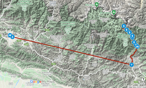
The Makalu region is within the Makalu-Barun National Park of Nepal. This is in the Eastern part of the country and lies next to the Kanchenjunga region then after that, there is the border with India. As the crow flies from Tumlingtar it is 186km to Kathmandu and only 110km to Darjeeling in India. Click on the Google Maps image below to see the trail to Makalu Base Camp.
A trekking holiday or expedition to Makalu starts with a flight on a twin-propeller plane. It takes about one hour to fly from Kathmandu to Tumlingtar airport. Tumlingtar is at an elevation of 285m and from there we drive by jeep to the small town of Num at 1,500m. During my Makalu expedition in 2009, we started our walk in from Tumlingtar.
Why is Makalu one of the best places to trek in Nepal?
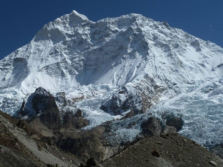
In my view, Mount Makalu is one of the most attractive of the 8,000m peaks after perhaps K2 in Pakistan. Makalu is a striking mountain and it is an impressive sight from all directions. Makalu has three prominent ridges: southeast ridge, west ridge, and northeast ridge. When I climbed to the summit of Mount Makalu in 2009 I followed the northeast ridge. This was the route of the first ascent by French climbers, Lionel Terray and Jean Couzy, on May 15th 1955.
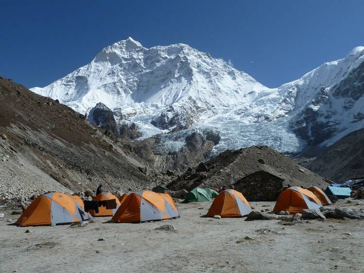
The view of the south face of Mount Makalu from Makalu Base Camp is incredible as it towers 3,500m above. There are superb walks around Makalu Base Camp to enjoy different viewpoints of this mountain. The best option is to walk up the slopes above camp to get to the base of the southeast ridge of Makalu. From here there are also fine views of Mount Everest and Mount Lhotse. This walk will take about 5 hours and reaches an altitude of 5,300m or higher if you have the energy!
Makalu is an under-explored and under-trekked region of Nepal. There are many possibilities for new hiking trails. There are valleys in the high mountains that have seen very few if any, trekkers. Take a look at a map of Makalu-Barun National Park and you will see remote places with no walking trails marked. Only a few pioneers like the ultrarunner, Lizzy Hawker, have explored these places.
The Great Himalaya Trail (“GHT”) is a network of trekking trails that traverses Nepal from East to West. The GHT passes through the Makalu region. The most remote and toughest route-finding is on Section One from Kanchenjunga to Makalu GHT. The crux of GHT with the most technical crossing is Sherpani Pass into the Everest region of Nepal.
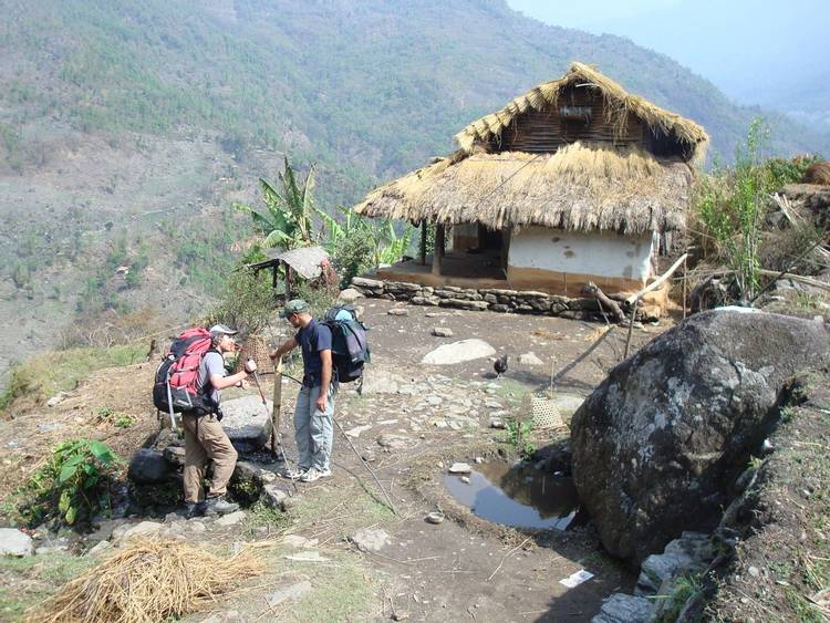
There are many attractions when trekking in Nepal beyond enjoying the mountain views. With a trek to Makalu, you will see a wide variety of landscapes. This is from subtropical vegetation at lower elevations to rhododendron forests and up to the high alpine zone. There are traditional Sherpa villages like Tashigaon before crossing Shipton La. You will see the rhythms of daily Nepalese life focussed around subsistence farming. Trekking in Makalu is like being in the Everest and Annapurna regions back in the 1970s.
Due to the remoteness of Makalu Barun National Park, there are undisturbed ecosystems. In these places, there is a high diversity of flora and fauna especially due to the range in altitudes. There are snow leopards, red panda and wild boars, and musk deer plus many more wild animals.
Makalu is not a restricted area so there are few official requirements such as expensive daily permits like for Upper Dolpo. There is no need to take a trekking guide so one can trek independently if one would like to do so.
Makalu is a beautiful place and I am always surprised there are so few other trekkers!
What factors make Makalu unpopular with the trekkers?
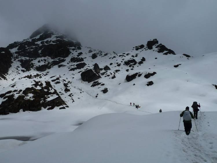
The main reason Makalu attracts a lower number of trekkers is due to the nature of the trek. Most people visiting this trekking area will do the walk to Makalu Base Camp. This is an “out and back” with a lot of ascent and descent on both legs of the trek. From Num, we descend to the Arun river then climb up over Shipton La then descend into the Barun Valley. You will reverse this on the way out! This tends to put people off while researching a trek in Nepal. However, in practice, everyone I know has very much enjoyed Makalu Base Camp. You will be very fit after this trek!
There is an option to avoid walking out on the same trail. Makalu to Everest GHT crosses the high passes of Sherpani Pass, West Col, and Amphu Lapsa over to the Everest region. Yet in practice, only a small number will make this journey. These high passes are over 6,000m are technical and require mountaineering experience.
Makalu to Everest GHT is probably the most difficult trek for an operator to organise in Nepal. Climbing Sherpas are needed to place fixed ropes on the passe to help the porters cross with their loads. In 2011, I led a group on Makalu to Everest GHT and it was a superb expedition in the high mountains. You can read more about how this went on our Trip Report Part One and Trip Report Part Two on our old Blog.
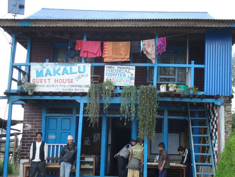
Makalu Base Camp only recently became a tea house-style trek. In practice, many groups are still doing this as a camping-style trek. Be aware there is a risk that the tea house lodges in the Barun Valley will be closed especially outside of the main trekking months. You should ask the owners at the teahouse lodges in Tashigaon village about this before crossing Shipton La. The teahouse lodges after Tashigaon will be basic compared to the Everest and Annapurna regions. If you book this trek with The Mountain Company we bring along tents. Most people prefer to sleep outside in tents and use the dining facilities in the lodges for meals.
The other factor impacting trekker numbers in Makalu is the distance from Kathmandu. As mentioned most hikers will fly to Tumlingtar. Flying in Nepal is quite expensive and there are safety risks. If you decide to drive this would take about 20 hours depending on the state of the road. Either way, this is a remote region, it takes time and money to travel to Makalu. One of the reasons Annapurna is the busiest trekking region in Nepal is due to its close accessibility to the town of Pokhara.
What are the trekking trails in the Makalu region?
1. Makalu Base Camp (or in the future perhaps "Makalu Circuit"?)
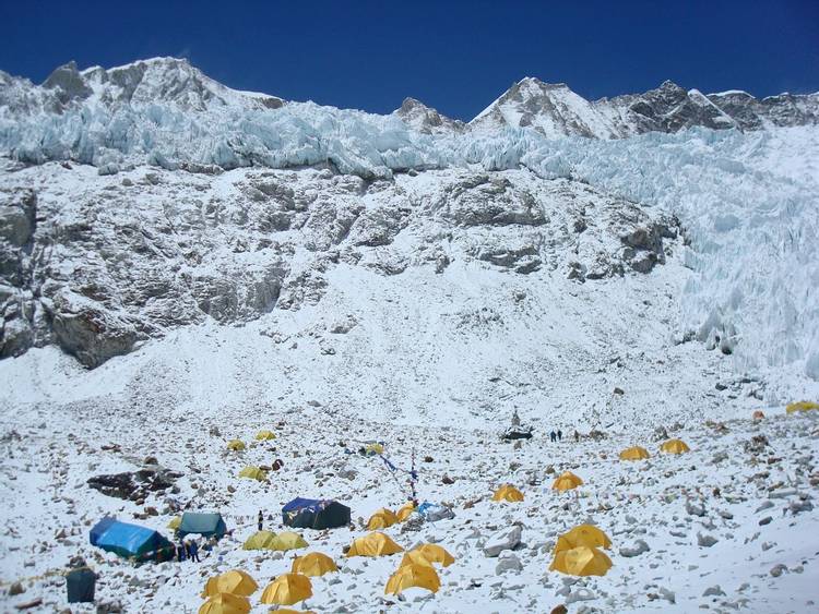
Makalu Base Camp is a journey to Mount Makalu and at 8,463m it is the fifth highest mountain in the world. Along the way, we have incredible views of Mount Makalu, Everest, Lhotse, and Chamlang. We start by flying to the Tumlingtar airstrip near the Arun River. We drive by jeeps to the village of Num. After crossing the Arun Valley on a suspension bridge we cross the Shipton La. We descend into the remote and beautiful Barun river valley. We stay at Makalu Base Camp for two nights and have one full day to explore the area and to enjoy the mountain views.
As mentioned above Makalu Base is an “out and back” trek. However, of interest, there have been plans for a number of years for a new trek called the "Makalu Circuit". This would be attractive to trekkers as it would avoid crossing Shipton La on the way back. The Makalu Circuit itinerary would follow a trail down the Barun valley from Yangle Kharka. This would continue to the confluence with the Arun river at a place called Doban.
In October 2014, I visited Doban to investigate the Makalu Circuit trail. Currently, there is a trail from Doban up to Yangle Kharka used by locals. It is narrow in places with several landslide areas plus there are no places to camp. While researching this blog, I had a discussion with Sian Pritchard-Jones and Bob Gibbons. Sian and Bob are very experienced trekkers and write guidebooks for the Himalayas. They gave me further information about the trail down to Barun valley. In December 2016, they trekked this trail known as the "Yeti Foot Trail" with their Nepalese guide, Sanjib Gurung.
It took Sian, Bob, and Sanjib three days of walking to descend from Yangle Kharka to Doban. Sian told me how the trail is very exposed and overgrown with vegetation in some places. There is very little room to camp and for the first night, the trek crew stayed in a cave under an overhanging rock. This trail will not be a viable option until improved by widening and campsite(s) constructed. If you are planning to trek this trail be very careful as rescue would be nearly impossible. You should only attempt this trail with a Nepalese guide who knows this trail well. For more information about the Yeti Foot Trail read Bob and Sian’s guidebook, the link is further down this blog.
When this trail has been improved it could make Makalu Base Camp/ Makalu Circuit one of the best treks in Nepal….however in practice, this is likely to take many years.
You can see the trekking route on our Google Maps for Makalu Base Camp
2. Makalu to Everest GHT over Sherpani Pass
You can see the trekking route on our Google Maps for Makalu to Everest GHT
3. Kanchenjunga to Makalu GHT
Kanchenjunga to Makalu GHT is a 36-day trek following Section One of The Great Himalaya Trail in Nepal. We start by walking to the Base Camp of Mount Kanchenjunga on the north side. After returning to Ghunsa we start walking on the remote section of GHT.
We cross the Nango La at 4,820m into the Yangma valley and to the village of Olangchungola. We cross Lumba Sumba pass at 5,160m and walk out to Hongon. We continue westwards along the rarely trekked high trail on the Makalu Base Camp trek. After visiting Makalu Base Camp we descend the Barun Valley then cross Shipton la at 4,125m. We walk out to Num then drive to Tumlingtar airstrip for the flight back to Kathmandu.
In 2013 I led a group crossing Lumba Sumba and went back in 2014 to complete the section from Hongon to Makalu Base Camp. You can read our 2013 Trip Report and 2014 Trip Report on our old Blog.
You can see the trekking route on our Google Maps for Kanchenjunga to Makalu GHT
4. Tumlingtar to Lukla over Salpa Bhanjang
I have walked the trail from Tumlingtar over Salpa Bhanjang to Lukla twice. Both times, I really enjoyed this trekking experience. The trail is an alternative to the other walk-in to the Everest region that goes from Jiri to Lukla. This is a good option for those who have more time and do not want to fly to Lukla.
Recently there has been road construction in the Solu Khumbu on the Jiri trail so it makes the walk from Tumlingtar a more attractive option. The trail from Tumlingtar over Salpa Bhanjang at 3,358m has a network of lodges along the way. Currently, The Mountain Company does not offer this itinerary but we will do so soon
When is the best time to trek in the Makalu region of Nepal?
Makalu is in the East of Nepal where there is more precipitation than in the West of the country. The monsoon approaches Nepal from the Bay Of Bengal so Eastern Nepal receives an earlier monsoon and later withdrawal. Shipton La holds winter snow into Springtime and it can be hard work crossing with deep snow especially for the porters. On our Makalu expedition in 2009, we crossed Shipton La during the first week of April. We broke trail through deep snow up to one metre deep in places. In the Spring season, it is better for trekkers to visit Makalu Base Camp in later April into early May.
In the Autumn season, most trekkers will visit during October. In most years this is the best month to visit Makalu Base Camp. Yet this is not always the case as in 2013 and 2014 there were cyclones!
For more information take a look at our Blog article When is the Best time to go trekking in the Nepal Himalaya?
Is it worth trekking to Makalu Advanced Base Camp?
Recently we had a question whether we could organise a trek to Makalu Advanced Base Camp (MABC) at an altitude of 5,650m. I was rather surprised as I knew that in practice trekkers very rarely make it to MABC. In Spring 2009, I spent seven weeks there when climbing Mount Makalu and we never saw any trekkers.
We do not include MABC in our Makalu Base Camp trek itinerary for several reasons. Firstly, the walk from Makalu Base Camp to MABC is a very difficult trail on loose scree and boulders. It is a slog and not very enjoyable, for most trekkers it would not be a pleasant experience.
The main issue is acclimatisation and the high risk of getting severe altitude sickness. To do it safely you have to add a lot of time to the itinerary for acclimatisation. To be properly acclimatised one should spend three nights at Makalu Base Camp at 4,900m and one at intermediate camp at 5,350m before ascending up to MABC.
I do not think the extra time on the trek on top of our 21-day Makalu Base Camp trek would be worthwhile. On the walk to MABC, you do not get good mountain views of Makalu as you are underneath the mountain so it is foreshortened. If you would like to see the best view of Makalu on a trail above Makalu Base Camp then this is from Sherpani Low Camp. The view of the West Ridge of Makalu from here is incredible. It is one of the most impressive sights that I have ever seen in the Himalayas. We follow this trail on our Makalu to Everest GHT trek.
How will development affect the Makalu region in the future?
Most of the Makalu-Barun National Park region is located away from the fast-expanding network of roads being built in Nepal. As mentioned earlier there is now a road from Tumlingtar to Num village at the start of the trek. Yet, by driving this is a benefit to the trip as one can access the more interesting places after Num.
The road to Num is part of a mega-project to build the Arun 3 hydroelectric power station. This will cost US$1.6 billion and export 900MW of power to India. After years of delay, in February 2020 the governments of India and Nepal signed the agreement.
Connected to Arun 3 is another project to extend the road from Num further up the Arun valley into Tibet/ China. The Arun river is one of the few rivers that cut through the Himalayas so is an obvious place to build a road. This is a significant engineering challenge and it will take time for the road to be completed. Fortunately, from a trekking point of view, this should not impact the trails in the Makalu region.
Therefore I think that Makalu will be less affected by development compared to other regions in Nepal. There is a new road close to Lukla in the Everest region and also there is a plan to build roads into Upper Dolpo.
What are the best maps and guidebooks for trekking in the Makalu region?
There is a lack of guidebooks to the Makalu region and perhaps this is another reason why the numbers of trekkers are so low. The best guidebook is A Trekking Guide to Makalu: Lumbasumba and Arun Valley by Sian Pritchard-Jones and Bob Gibbons.
There are several maps to the Makalu region. As ever with maps in Nepal, these are helpful for general information but there are often errors and inconsistencies. Take a look at the following maps published by Himalayan Map House:
Makalu region NP102 Trekking Map Series 1:100,000
Makalu Base Camp NE511 1:80,000
Tumlingtar to Lukla NE515 1:125,000
Our Conclusion
Treks in the Makalu region are some of the best in the Nepalese Himalaya. There is a range of trails from teahouse lodge style to camping style. The new lodges on the Makalu Base Camp make this a good option for many people. One of the most remote treks anywhere in the Himalayas is Kanchenjunga to Makalu GHT. If you are looking for a mountaineering-style trek then Makalu to Everest GHT would be an excellent choice.
It is always a surprise to me to see how few trekkers visit Makalu. But do not let the low numbers put you off. In fact, the quiet trails make for an incredible trekking experience. My view is that the Makalu region will get more popular in the future. Especially as the trails should be less affected by road construction compared to some of the other trekking regions of Nepal. You had better arrange a trek in the Makalu region before it gets too busy! If you would like help in organising your trekking holiday please get in touch with us.